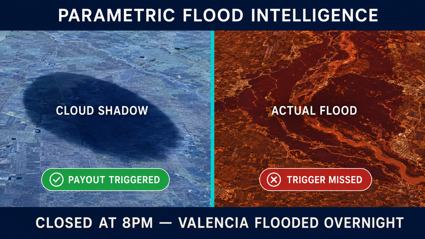
Single-frame optical satellite imagery cannot reliably distinguish cloud shadows from floodwater. This isn't a matter of algorithm sophistication — it's physics. Cloud shadows and inundated terrain suppress near-infrared and shortwave infrared reflectance through nearly identical mechanisms. The standard water detection indices parametric insurance triggers depend on — NDWI and MNDWI — flag both as water-like because the spectral physics is the same. When a $2M parametric payout depends on that classification, "probably flooded" is not a defensible actuarial answer.
Two incidents from the past eighteen months make the cost concrete in opposite directions. Valencia, Spain, October 2024: a year's worth of rain fell in eight hours, 227 people died, and the Copernicus Emergency Management Service — the satellite-mapping system Europe relies on for disaster response — took three to four days to publish flood extent analysis. The confirmed result was 15,633 hectares flooded, roughly 190,000 people affected, arriving structurally too late. Copernicus EMS Service Level 2 operates 08:00–20:00 Brussels time on working days only; Valencia's critical first twenty-four hours overlapped with evening and overnight. The system wasn't slow. It was closed.
In Nagaland, India, the failure ran the opposite direction. A parametric flood insurance scheme failed to trigger despite heavy rainfall and confirmed on-the-ground flooding. The satellite-derived threshold was calibrated too high relative to ground reality. Policyholders paid premiums; the satellite returned a null event.
Both failures emerge from the same underlying gap: satellite flood detection is harder than vendor marketing suggests, and no single product resolves both failure modes simultaneously.
Why Every Vendor Has the Same Architectural Problem
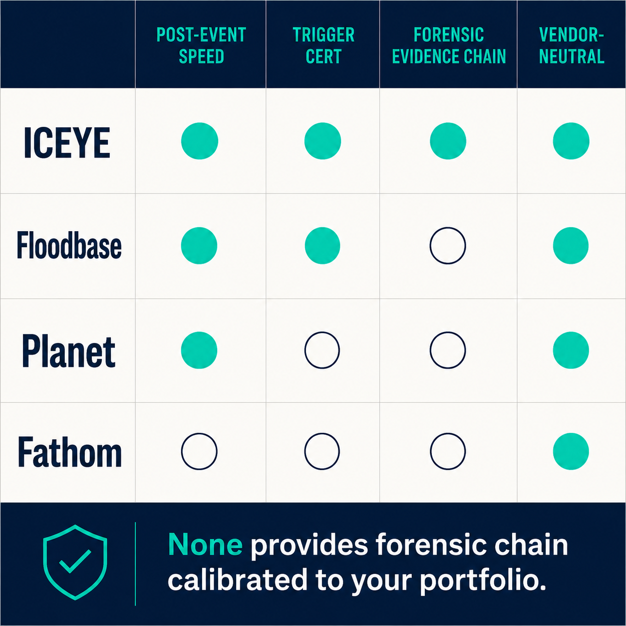
ICEYE operates the world's largest commercial SAR constellation — more than 60 satellites — and its Flood Rapid Impact product delivers post-event reports in six to twelve hours. Its partnership with Munich Re's Risk Management Partners (January 2026) and its strategic arrangement with Swiss Re signal that the reinsurance sector is betting heavily on ICEYE's capabilities. In the 2024 hurricane season, ICEYE captured more than 150 images of Hurricane Helene's impact through active storm clouds and mapped over 80,000 buildings in Florida. The capability is real.
But ICEYE's product gives buyers access to ICEYE's methodology — not a system tuned to their specific portfolio's trigger thresholds, cover regions, and basis risk profile. The same structural limit applies to Floodbase (formerly Cloud to Street), which fuses seventeen optical and radar satellites and has designed end-to-end parametric trigger and certification systems for programs backed by Munich Re in Colombia. Its Capella Space partnership extends SAR coverage, and its trigger certification approach is substantive. What you're buying is their trigger design, not a forensic intelligence capability calibrated to your book.
Planet Labs' fleet of more than 200 optical satellites delivers daily global coverage at three-meter resolution — excellent for baseline and change detection monitoring. During an active flood event, under 100 percent storm cloud cover, the optical constellation is effectively blind. Fathom, integrated into Swiss Re's internal catastrophe model in early 2026, focuses on probabilistic flood hazard modeling: the right tool for pre-event risk pricing, not for post-event trigger verification.
When the EU's designated flood-mapping service operates business hours only, the infrastructure gap isn't a budget problem. It's a design problem — and the same design gap exists at the product level across every vertically integrated satellite platform.
The structural problem isn't a product deficiency — it's an ecosystem constraint. Vertically integrated platforms optimize for delivering within their own sensor footprint and their own methodology. None of them were designed to answer the question a parametric underwriter actually faces at payout time: is the specific trigger zone for this specific policy actually flooded, with pixel-level confidence intervals and a defensible audit trail?
What a Temporal Stack Resolves — and What It Doesn't
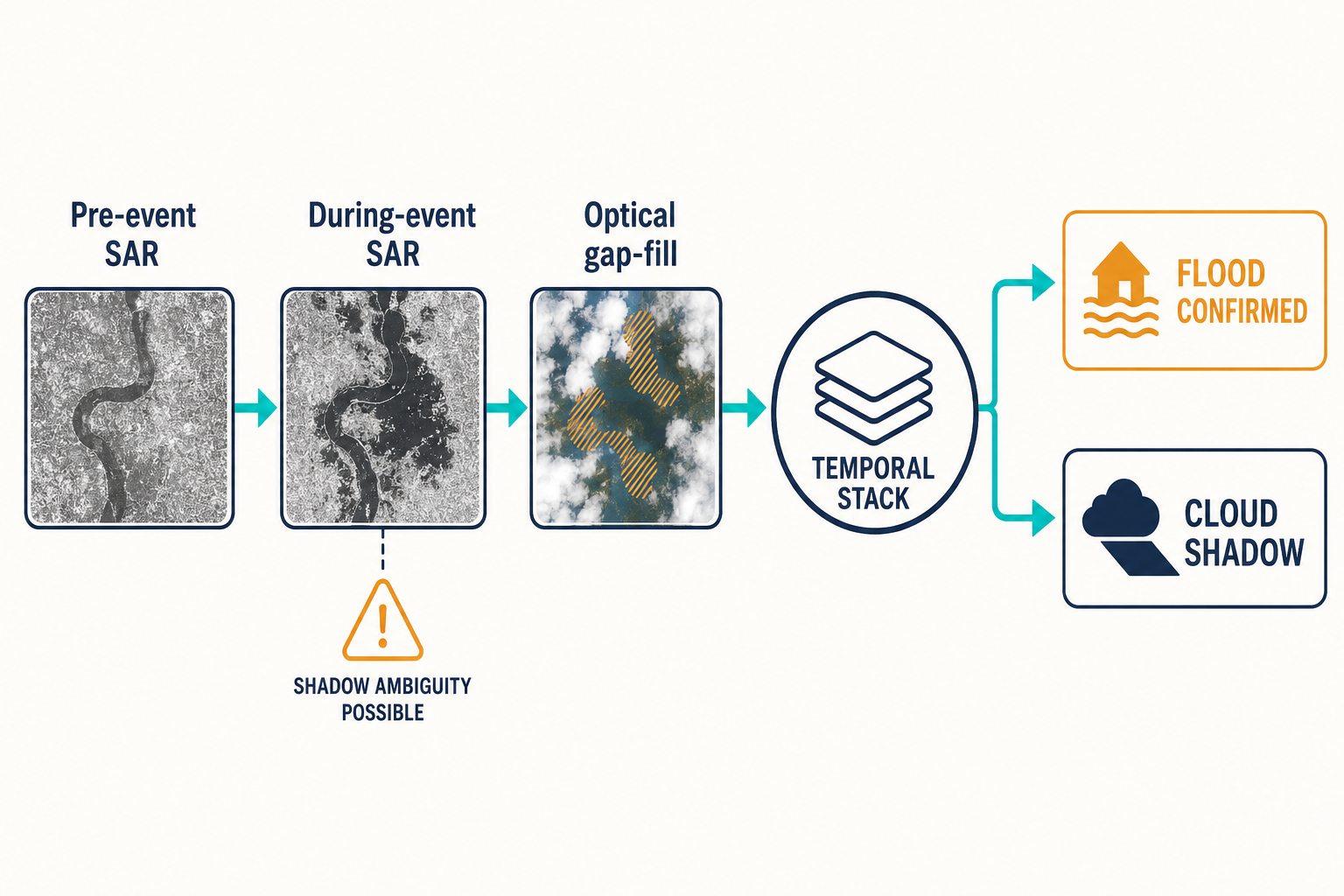
Synthetic aperture radar is often presented as the solution to the optical cloud-shadow problem. When Sentinel-1's VV-polarization backscatter hits smooth water, the signal reflects away from the sensor (specular reflection) rather than back to it — creating a signature drop that reads as inundation while cloud cover has no effect on the signal. The logic is sound.
The complication is that backscatter drops not only over water but also over terrain shadows in mountainous areas, due to radar layover and foreshortening. SAR produces its own ambiguity. NASA's operational experience with its LANCE near-real-time flood product confirms the practical consequence: the one-day composite is suppressed entirely from NASA's Worldview visualization tool because the false positive rate is operationally unacceptable. Only two-day and three-day composites, which use temporal persistence to filter noise, are released for end users. Permanent water masks misclassify new reservoirs as flood events for up to three years until the baseline updates.
The real signal isn't in a single SAR acquisition. It's in comparing how a specific patch of ground behaves across multiple passes before, during, and after a flood event — and fusing that temporal behavior with optical data when cloud windows open.
Research published in Nature Communications (2025) using ten years of Sentinel-1 data demonstrates what temporal stack analysis makes possible: overall accuracy of 0.9840, F1 of 0.9207 using modified DeepLabV3 with multi-polarization SAR and terrain correction. SAR and multispectral fusion improved detection in cloud-shadow areas by more than 23.64 percent compared to single-sensor approaches. The accuracy threshold is achievable. The production question is whether the infrastructure exists to assemble temporal stacks at the speed parametric triggers require.
The Sentinel-1 constellation restoration helps on the data access side: Sentinel-1C launched December 2024 and reached operational status in May 2025; Sentinel-1D followed in November 2025, restoring six-day revisit frequency on free data. That interval is still insufficient for real-time monitoring during a fast-moving flood event — commercial SAR at $1,000 to $5,000 or more per scene (depending on resolution and urgency) needs to supplement the free baseline for rapid-trigger parametric programs.
The Trigger Certificate Is the Product
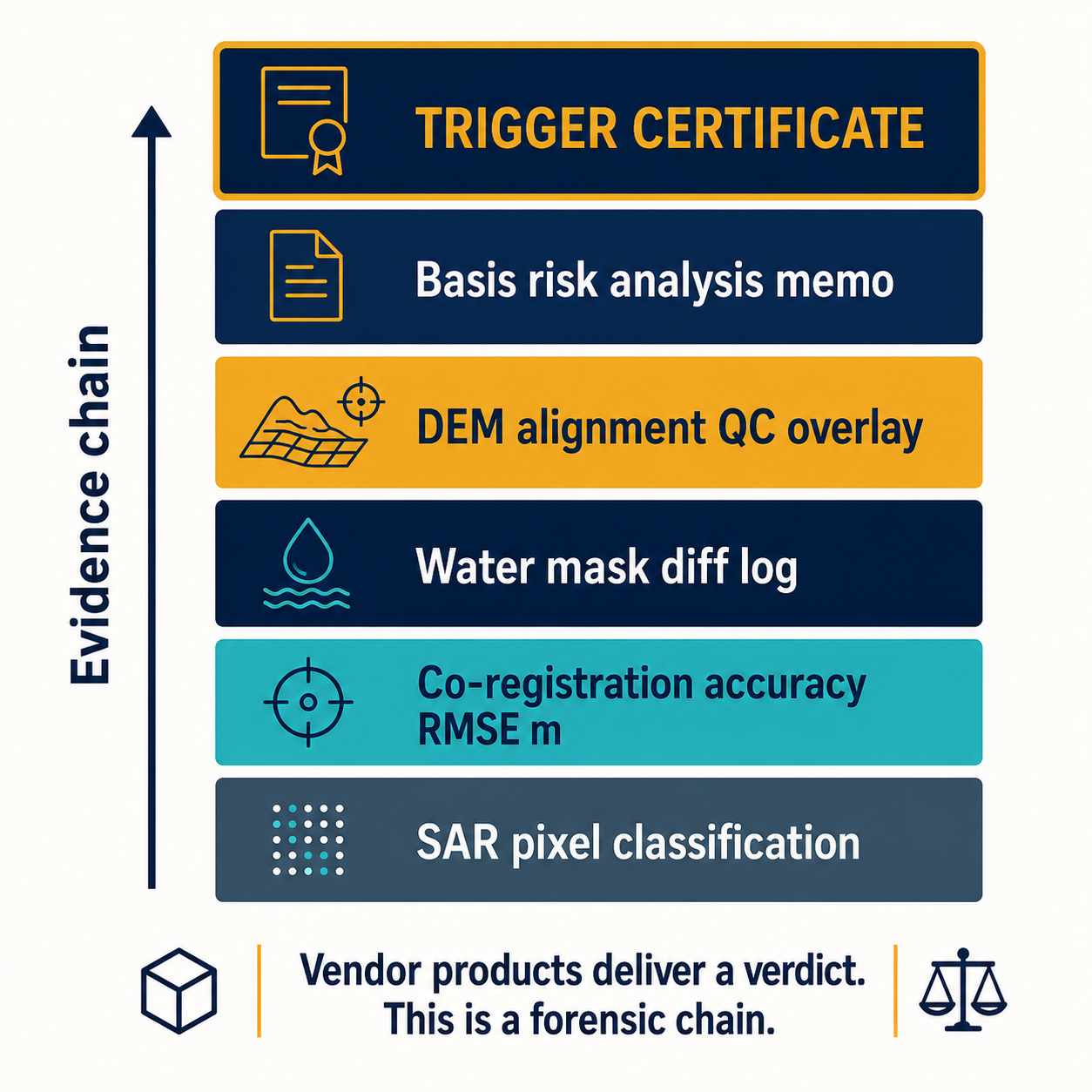
When a parametric policy triggers and a multi-million-dollar payout follows, the evidence chain doesn't end at the satellite image. The trigger certificate — the document an actuary signs to authorize the payout — needs to withstand audit by the reinsurer, the regulator, and potentially a court. The flood extent polygon attached to the loss adjustment worksheet must be traceable to the pixel-level classification decision that generated it.
What that requires in practice: SAR-optical co-registration accuracy reports (in meters of RMSE, not just a confidence label), permanent water mask diff logs showing whether any classified flood zone was a newly formed reservoir not yet updated in the baseline, hydrological DEM alignment quality-control overlays confirming the floodplain mask was properly constrained, and a basis risk analysis memo comparing the satellite trigger zone to gauge-station records where they exist.
A trigger certificate doesn't certify the satellite image. It certifies the evidence chain — and that chain has to survive actuarial review, reinsurer audit, and potentially a federal court.
Vendor-provided products deliver a verdict. Forensic-grade verification delivers an evidence chain. The distinction matters when the verdict gets disputed — and as programs scale, the disputes follow.
Our work at Veriprajna's satellite flood intelligence page is built around the evidence chain rather than the verdict. Not locked into any single constellation — fusing Sentinel-1 and -2, Capella, ICEYE, Umbra, Planet data based on availability and the specific cover requirements of the program — and integrated directly into the cat model, claims management, or disaster response workflow the client already operates.
A 61% Protection Gap Cannot Tolerate False Negatives
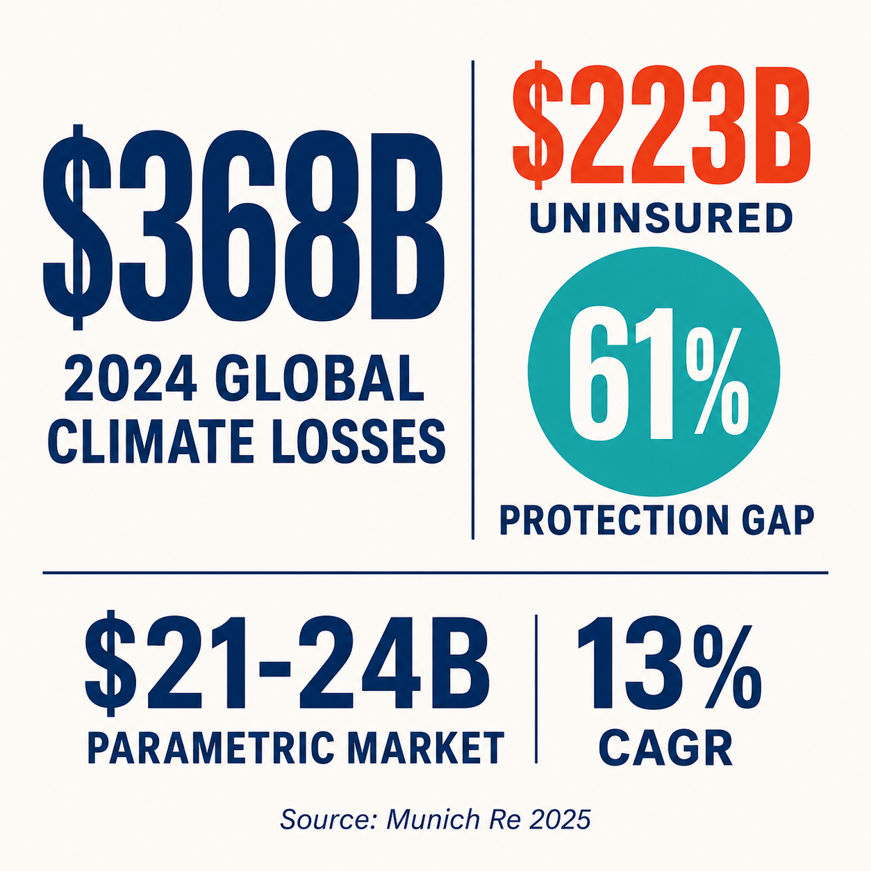
The numbers that frame this problem are no longer projections. 2024 saw $368 billion in climate disaster losses globally, with $223 billion uninsured — a protection gap approaching 61 percent (Munich Re, 2025). The Texas floods of July 2025 produced 135 deaths; the Guadalupe River rose 31 feet in 90 minutes, the deadliest US inland flood event in five decades.
The parametric insurance market exists to close this gap. Currently valued at $21–24 billion and growing at roughly 13 percent annually, the sector has begun making the ambition concrete: the Lagos parametric flood insurance program, launched March 2026, covers four million people through AXA Climate, Swiss Re, JBA Risk Management, ICEYE, and African Risk Capacity. These are not proof-of-concept programs anymore.
Every false positive weakens the actuarial case for parametric products. Every false negative — the Nagaland shape of failure — destroys policyholder trust in a market that hasn't yet earned deep reserves of it. Both failure modes are the same underlying problem: trigger fidelity hasn't kept pace with program ambition.
Where the Field Is Going
The accuracy benchmarks from temporal SAR-optical research are mature enough to solve the physics problem. The remaining gap is systematic: assembling temporal stacks at the speed parametric triggers require, fusing multi-constellation data without locking into one provider's footprint, and producing the forensic documentation that makes the trigger certificate defensible across audit scenarios.
That's an engineering and systems integration problem, not a data availability problem. The satellite data exists. Sentinel-1 is free. Capella and ICEYE have APIs. The field has sufficient research on what temporal fusion achieves. What's missing in most programs is the production infrastructure to do it at the scale and speed the trigger window requires — and the evidence-chain discipline to produce a certificate that holds.
If your team is navigating the trigger fidelity question — whether you're an underwriter working to eliminate false positives, a reinsurer auditing an existing portfolio's trigger methodology, or a disaster response agency trying to close the kind of gap that cost Valencia three days — we'd like to understand what specific failure mode you're encountering.
The programs are proliferating because the protection gap demands them. Whether trigger fidelity keeps pace will determine whether parametric insurance earns the trust that scale of demand requires.