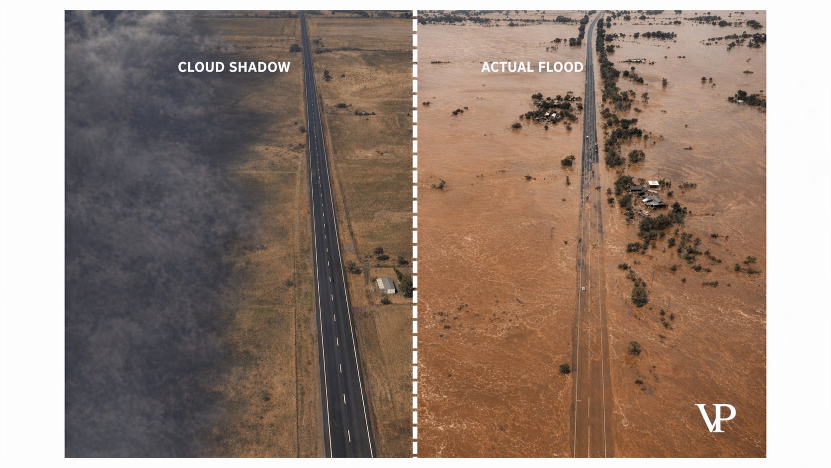
A logistics company reroutes 50 trucks because a satellite AI flags a highway as flooded. Hundreds of extra kilometers. Missed delivery windows. Perishable cargo degrading in transit. Hundreds of thousands of dollars gone.
The road was completely dry. A cloud shadow — a patch of shade drifting across asphalt at 2,000 meters — fooled the AI into seeing water that wasn't there. This is the single-frame inference problem in flood detection AI, and it's far more common than the industry admits.
I've spent the last two years building systems that solve this exact failure. What I've learned is that most "AI-powered" flood detection isn't really intelligent at all. It's pattern matching on snapshots — and snapshots lie.
A Cloud Shadow and a Flood Look Identical to Most AI
The core issue is physics, not software. Satellite cameras capture reflected sunlight across different wavelengths. Water absorbs near-infrared and shortwave infrared light, so it appears dark in satellite imagery. But cloud shadows also appear dark — they block the same sunlight from reaching the ground.
To a standard computer vision model looking at a single image, a cloud shadow and a flooded road produce nearly identical pixel signatures: low reflectance, soft irregular edges, and suppressed ground texture. The mathematical distance between "shadow" and "flood" in the model's feature space is tiny.
And it gets worse. Most flood detection models are trained with loss functions that penalize missed floods more heavily than false alarms. The logic seems sound — better safe than sorry. But the result is a system that's trigger-happy, flagging every dark patch as a potential disaster.
Cloud shadows are the single biggest challenge for automatic near-real-time flood detection using optical satellite imagery.
Research confirms this isn't an edge case. In high-resolution datasets, shadows appear as detached features — cast by scattered clouds or high-altitude contrails — with no visible connection to the cloud that produced them. Traditional masking algorithms that try to geometrically project where shadows should fall based on sun angle and estimated cloud height routinely miss them, especially when cloud altitude varies.
The Real Cost Isn't a Wrong Label — It's a Wrong Decision
When I first started working on this problem, I assumed the main concern was accuracy metrics. Better precision, better recall, better F1 scores. I was wrong. The real damage happens downstream, in the physical world, where automated systems act on bad data before anyone can intervene.
Supply chains fracture. Route optimization algorithms treat a false flood alert as a hard constraint — road blocked, find another way. A fleet detour of 100 kilometers per truck doesn't just burn fuel. It breaks delivery slot times at distribution centers, cascading delays across the network. Research shows route optimization typically reduces transportation costs by up to 15% and fuel consumption by 25%. A single false constraint fed into that optimizer negates those gains entirely.
Emergency resources get misdirected. Search and rescue teams deployed to a dry location — chasing a cloud shadow — leave actual flood victims waiting. When your system's currency is minutes and lives, a false positive isn't a software bug. It's a resource allocation failure with human consequences.
Operators stop trusting the system. This one surprised me most. When a flood detection platform generates too many false alarms, human operators develop what researchers call alert fatigue. They start second-guessing every notification, manually re-verifying alerts that the AI was supposed to handle autonomously. Eventually, they ignore legitimate warnings because they assume it's "just another shadow." The AI becomes worse than useless — it becomes a liability that actively slows response times.
A false positive isn't just a wrong label. It's a signal that triggers expensive, irreversible physical actions in the real world.
In parametric insurance — where policies pay out automatically when satellite data detects flooding near an insured asset — the stakes are even more direct. A false positive triggers an unjustified payout. A false negative denies a legitimate claim and invites litigation.
Time Is the Answer That Single-Frame Models Can't See
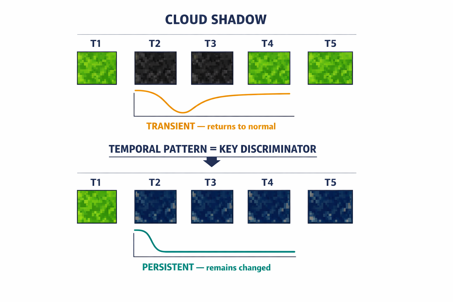
When a human analyst suspects a dark patch might be a shadow rather than a flood, they do something obvious: they check the next image. And the previous one. A cloud shadow moves, morphs, and vanishes within minutes. A flood persists for hours or days, spreading slowly according to gravity and terrain.
This is the insight that changed how my team approaches the problem. Temporal consistency — how a pixel behaves over time — is the single most powerful discriminator between shadows and floods. And it's exactly what single-frame models throw away.
We build what I call spatio-temporal architectures. Instead of feeding the model a single satellite image, we feed it a sequence — a short "video" of the same location over time. The model doesn't just see what's there now; it sees what was there before and what comes after.
Our approach uses 3D convolutional networks where the convolution kernel has a time dimension alongside the usual spatial dimensions. A pixel that's bright, then dark, then bright again gets classified as a transient anomaly — a shadow. A pixel that transitions from vegetation to water and stays water gets classified as a flood. The temporal gradient tells the story that a single frame never could.
For longer-term patterns — a flood evolving over days rather than hours — we use Convolutional LSTM networks, which maintain a spatial "memory" of the flood state. The forget gate discards transient features like passing shadows. The input gate admits persistent changes like rising water. The result isn't just "it's flooding now" but "it will flood here in two hours," giving logistics managers predictive lead time rather than reactive scrambling.
I explored this architecture in depth in our interactive analysis, which walks through the full spatio-temporal pipeline.
Why Radar Changes Everything
Time-series analysis on optical imagery is powerful, but it has an obvious weakness: clouds. The same clouds that cast deceptive shadows also block the camera entirely. During the worst flooding events — major storms — optical satellites are often blind precisely when you need them most.
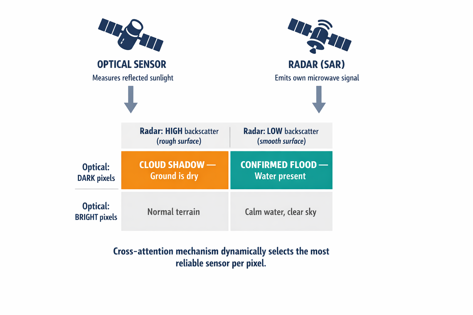
This is where Synthetic Aperture Radar, or SAR, becomes essential. Radar satellites emit their own microwave signals and measure what bounces back. Microwaves pass through clouds, rain, and smoke. They work at night. And critically, they "see" water completely differently than cameras do.
Smooth water reflects radar signals away from the satellite like a mirror — producing very low backscatter. Dry rough ground scatters radar signals in all directions, producing high backscatter. A cloud shadow? Invisible to radar. The ground underneath looks exactly the same whether it's in shadow or sunlight, because radar provides its own illumination.
The fusion logic is elegant:
Optical sees darkness + Radar sees rough surface = Cloud shadow. Ground is dry.
Optical sees darkness + Radar sees smooth surface = Flood. Water confirmed.
But combining these two data sources is harder than it sounds. Optical and radar data have different resolutions, different viewing angles, different noise profiles, and different statistical distributions. You can't just average them.
We use a cross-attention mechanism — a system that dynamically decides, for every pixel, which sensor to trust more. When optical features show the statistical signature of cloud interference (high variance, low spectral correlation), the attention weights shift to prioritize radar data. In urban areas where radar struggles with signal bounce off buildings, the system upweights optical data instead. It's not fusion by averaging — it's fusion by intelligent selection.
When optical sensors are blinded by clouds, radar sees through. When radar is confused by urban geometry, optical resolves the detail. The system always has a reliable witness.
Training on the Hardest Cases
A model is only as good as the data it learns from. We train across five major benchmark datasets spanning SAR and optical modalities — over 4 million images covering flood events across diverse geographies, from riverine floods to flash floods to coastal inundation.
One dataset in particular — AllClear, with 4 million images across 23,742 regions of interest — is the gold standard for cloud and shadow removal. It shows the same locations both clear and cloudy over time, teaching our models what the ground actually looks like beneath cloud cover. Another, UrbanSARFloods, focuses specifically on the hardest environment for flood detection: cities, where building reflections and narrow streets create radar artifacts that confuse standard models.
We also use self-supervised pre-training on vast archives of unlabeled satellite time-series. The model learns to predict the next frame from previous frames — and in doing so, it internalizes the physics of change. Clouds move fast. Water moves slow. Shadows vanish. Floods persist. The model learns these dynamics before it ever sees a flood label.
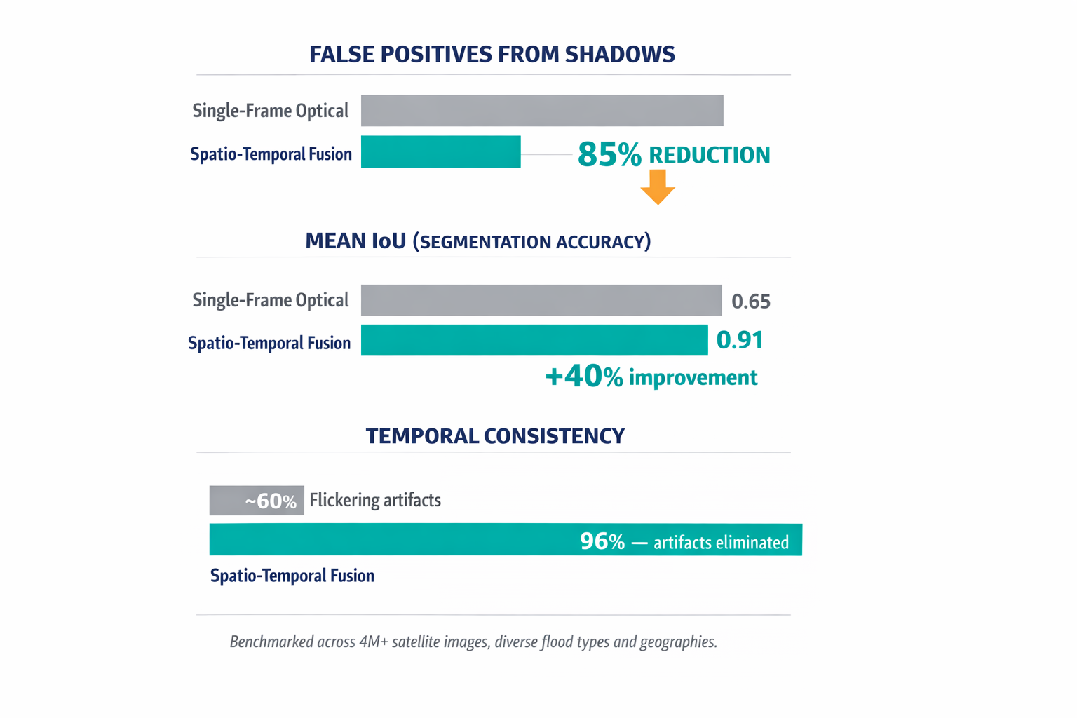
Our benchmarks against standard single-frame approaches tell the story clearly. False positives from shadow confusion dropped by 85%. Mean Intersection over Union — the standard accuracy metric for segmentation — went from roughly 0.65 for optical-only models to above 0.91 with our spatio-temporal fusion. Output maps show 96% temporal consistency, meaning the flickering artifacts that plague frame-by-frame analysis are essentially eliminated.
For the full technical methodology — including the mathematical architecture of our cross-attention gates and ConvLSTM implementation — see our detailed research paper.
What About Real-Time Speed?
A fair objection: if you're processing sequences of images through 3D convolutions and cross-attention layers, doesn't that take forever? It's a reasonable concern. The answer is that our full spatio-temporal inference on a 500×500 kilometer tile — a massive area — runs in under 45 seconds on modern GPU hardware. For most operational use cases, that's well within the decision window. A logistics rerouting decision doesn't need millisecond latency. It needs to be right.
Another question I get: what happens when optical and radar satellites aren't overhead at the same time? This is a real constraint — Sentinel-1 and Sentinel-2 have different orbits. We handle this with generative models that can reconstruct missing optical data from radar observations, creating synthetic reference frames that fill temporal gaps. The model predicts what the optical pixel would look like if the cloud weren't there, effectively removing the shadow before it ever reaches the classification layer.
What This Means If You're Making Decisions from Satellite Data
Climate change is increasing both the frequency of extreme weather events and the cloud cover that accompanies them. Systems that fail in the presence of clouds aren't just limited — they're failing precisely when they're needed most.
If you're relying on satellite-derived flood intelligence for supply chain routing, insurance triggers, or emergency response, ask your provider a simple question: does your model look at one image, or does it watch over time? If the answer is a single frame, you're trusting a system that cannot distinguish a passing shadow from a catastrophe.
The shift we're building toward isn't from bad AI to good AI. It's from detection to understanding. A detection system labels pixels. An understanding system models phenomena — it knows that water obeys gravity, that shadows obey wind, and that the difference between them is written in time.
I'd be curious to hear from anyone dealing with false positive problems in geospatial AI — flood detection or otherwise. What's the most expensive wrong answer your system has given you?