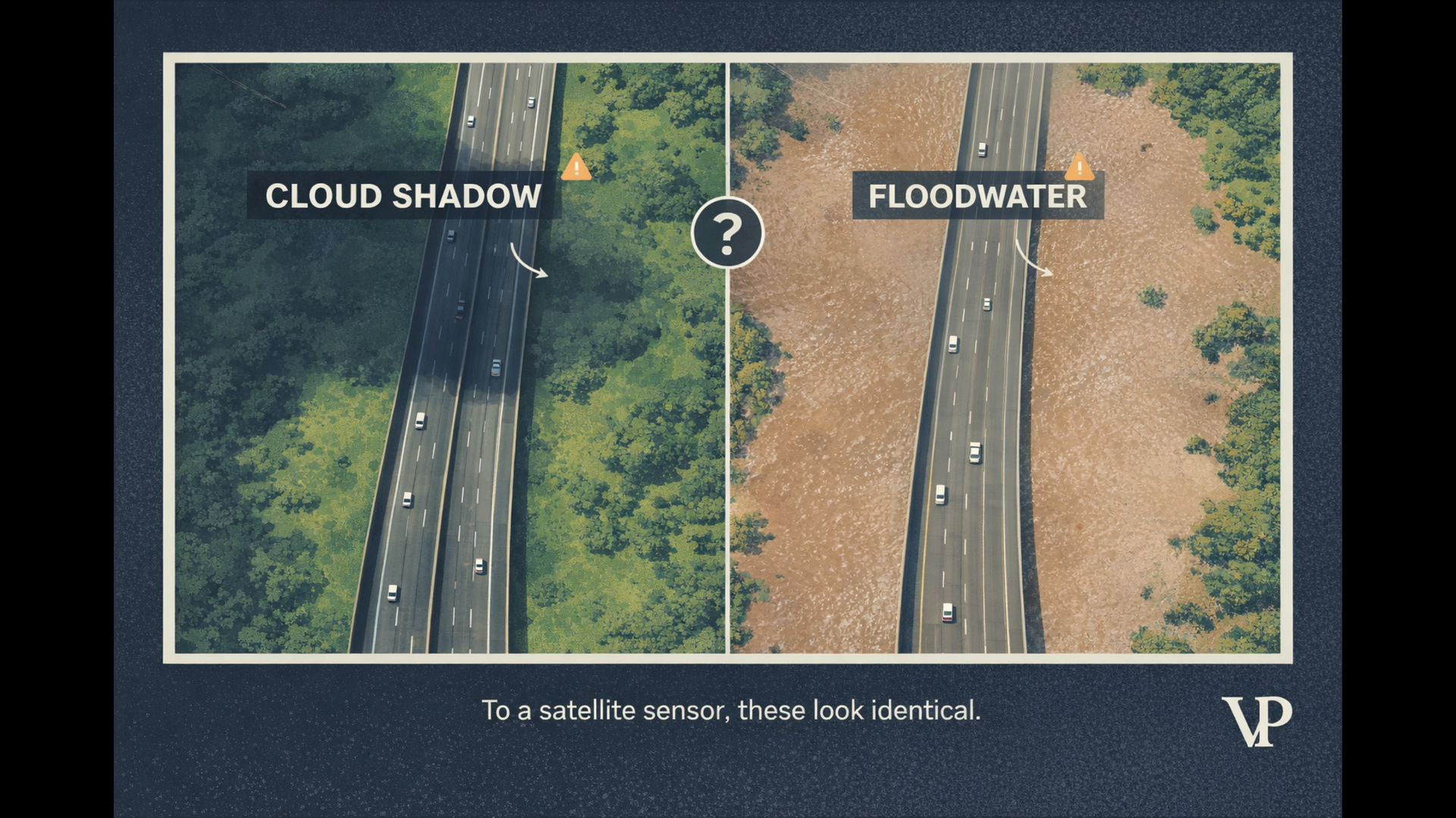
A logistics company's AI flagged a critical highway as flooded. Automated rerouting kicked in. Fifty trucks detoured an extra hundred kilometers. Perishable cargo spoiled. The cost ran into hundreds of thousands of dollars.
The road was completely dry. A cloud shadow — a patch of shade drifting across the asphalt — had fooled the system. The AI looked at a single satellite image, saw a dark shape on the road, and concluded: water. This is the single-frame inference problem, and it's quietly draining money, trust, and operational reliability from enterprises that depend on satellite-based flood detection AI.
We've spent years engineering systems that solve this exact failure. What we've learned is that the problem isn't bad AI — it's AI that doesn't understand time.
A Cloud Shadow and a Flood Look Identical in a Photograph
To a satellite camera, water is dark. It absorbs near-infrared and shortwave infrared light, so it shows up as a black or near-black patch in imagery. But water isn't the only thing that's dark. Cloud shadows, terrain shadows from mountains, and even fresh asphalt all produce nearly identical pixel values.
A standard AI model trained on static satellite images works like a pattern matcher. It learns: "dark, amorphous shape on a road = water." And most of the time, that heuristic works. But when a cumulus cloud drifts overhead and casts a shadow that has soft edges, suppresses the texture of the ground below it, and spans an irregular area — the model can't tell the difference.
A cloud shadow moves at 50 km/h. Floodwater doesn't. But a single photograph can't show you speed.
Research confirms that cloud shadows are the single biggest challenge for automatic near-real-time flood detection using optical satellite imagery. In high-resolution datasets, shadows frequently appear as detached features — disconnected from the cloud that cast them — making even geometric correction methods unreliable when cloud height is unknown.
The traditional fix is algorithmic masking: rule-based systems like Fmask that try to identify clouds and their shadows before the AI ever sees the image. These masks rely on thermal bands and brightness thresholds. They're brittle. Thin clouds don't trigger them. Wrong assumptions about cloud height put the predicted shadow in the wrong place. And any "wrapper" AI solution built on top of these masks inherits every one of their errors.
The Real Cost of Phantom Floods
A false flood alert isn't a minor inconvenience. It's a signal that triggers expensive, irreversible actions in the physical world.
In logistics, route optimization typically reduces transportation costs by up to 15% and fuel consumption by 25%. A phantom flood on a major route forces the optimizer into a worse solution — longer distances, missed delivery windows, cascading delays at distribution centers. Worse, a perceived disruption at one node can trigger the Bullwhip Effect: upstream suppliers panic-order materials, inventories bloat, and capital gets locked up in stock nobody needs.
In disaster response, the cost is measured differently. Deploying search-and-rescue teams to a dry location means actual flood victims elsewhere wait longer. And when false alarms happen repeatedly, operators stop trusting the system entirely. This is alert fatigue — the "cry wolf" scenario where legitimate warnings get ignored because the last five were shadows. Research shows that teams facing constant false positives experience burnout, higher turnover, and a fundamental erosion of trust in automated systems.
In parametric insurance, satellite data triggers automatic payouts. A false positive means an unjustified payout hitting the loss ratio. A false negative means a denied claim and a lawsuit. The margin for error is essentially zero.
We explored these cascading economic impacts in detail in our interactive analysis of enterprise flood intelligence.
Time Is the Test That Shadows Fail
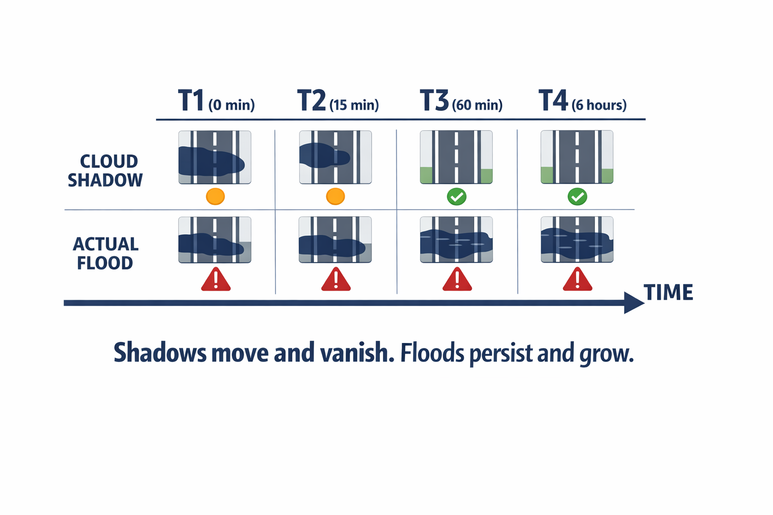
How does a human analyst verify whether a dark patch is a shadow or a flood? They wait. They check the next image. They look at what the same spot looked like an hour ago.
A cloud shadow moves, morphs, and vanishes within minutes. A flood persists for hours or days, evolving slowly according to gravity and terrain. Temporal consistency is the ground truth that single-frame AI throws away.
Our systems don't analyze photographs. They analyze sequences — treating time as a fundamental dimension of the data, not an afterthought. Think of it as the difference between looking at a single frame from a security camera versus watching the full video. One frame shows a dark shape in a parking lot. The video shows it's a shadow that sweeps across in thirty seconds.
We use two complementary approaches to build this temporal understanding:
3D convolutional neural networks extend the standard image-processing kernel into the time dimension. Instead of scanning a flat image for spatial patterns (edges, textures, shapes), the kernel scans across a stack of sequential frames. It learns that a pixel bright at time 1, dark at time 2, and bright again at time 3 is a transient anomaly — a shadow passing through. A pixel that turns dark and stays dark for hours is something else entirely. Research shows these 3D architectures significantly outperform frame-by-frame baselines, especially in complex urban environments where building shadows and cloud shadows overlap.
Recurrent memory networks (specifically, Convolutional LSTMs) handle longer timescales. They maintain a running "flood probability map" that resists rapid fluctuations but updates when consistent change is observed. A passing shadow gets discarded from memory. Rising floodwater gets admitted. This architecture doesn't just say "it's flooding" — it can predict "it will flood here in two hours," giving logistics managers actual lead time.
We don't just detect pixels. We watch the flow of time.
Our benchmarks show that this temporal approach achieves 96% trend consistency in output maps — meaning the results are stable and operationally reliable, not flickering between "flood" and "dry" every time the lighting changes.
Seeing Through Clouds With Radar
Temporal analysis solves the shadow problem when you have multiple clear images over time. But what happens during the storms that cause actual floods — when the sky is completely overcast and optical satellites are blind?
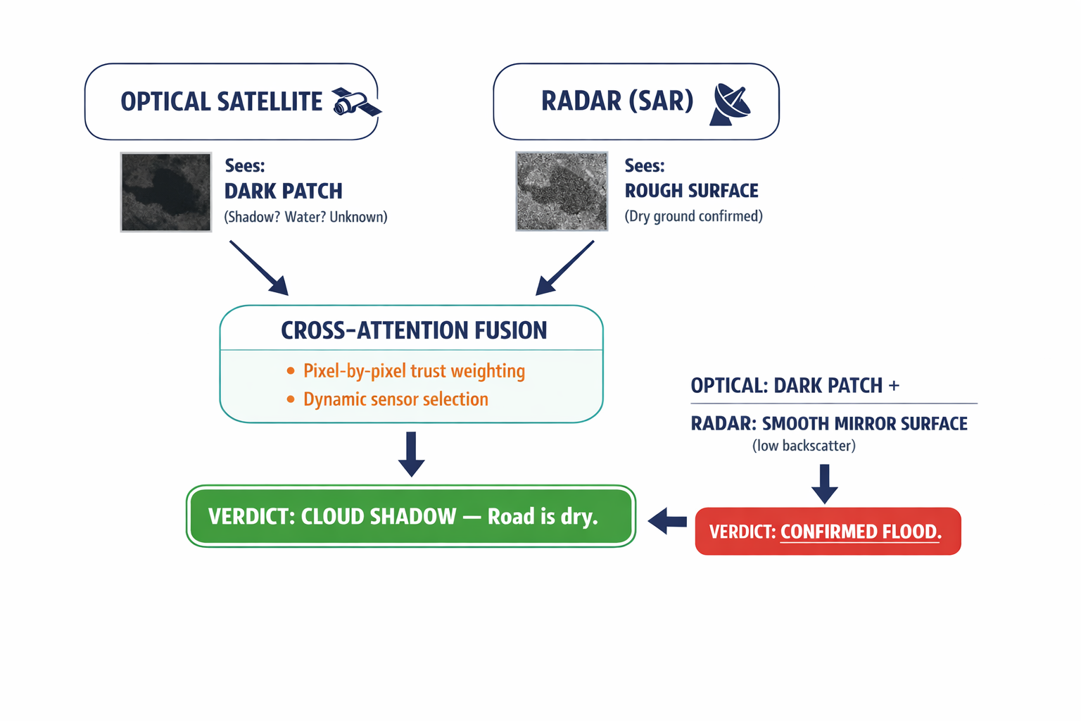
This is where sensor fusion becomes essential. Optical satellites capture reflected sunlight — they see roughly what your eyes see. Synthetic Aperture Radar (SAR) is fundamentally different: it emits its own microwave pulses and listens for the echo. Microwaves pass through clouds, rain, and smoke. They work day and night. And critically, a cloud shadow is invisible to radar because radar provides its own illumination.
The fusion logic is elegant in principle. When the optical sensor sees darkness and the radar sees a rough surface (high backscatter echo), that's a shadow — the ground is dry. When the optical sensor sees darkness and the radar sees a smooth, mirror-like surface (low backscatter), that's water.
Execution is harder. Optical and radar data have completely different statistical properties, resolutions, and noise profiles. Simply averaging two models' outputs doesn't capture the interactions between them. Stacking the raw data into a single input overwhelms the network with incompatible number ranges.
Our approach uses cross-attention mechanisms — a technique that lets the system dynamically decide which sensor to trust for each individual pixel. When the optical data shows cloud noise, the attention weights shift toward radar. In urban areas where radar struggles with signal bounce off buildings, the weights shift back toward optical data if the sky is clear. It's not a fixed rule. The system learns, pixel by pixel, which source of information is more reliable in that specific context.
The AI doesn't average two sensors. It actively selects the source of truth for every pixel in the scene.
This dynamic trust allocation is what separates deep fusion from the "wrapper" approach of running two separate models and hoping they agree.
What About Urban Environments?
Cities are the hardest test case for flood detection AI. Buildings create radar artifacts called "double bounce" — microwave signals ricochet between walls and the ground, producing false signatures that can mask actual street-level flooding. Meanwhile, optical imagery in cities is cluttered with dark rooftops, parking lots, and building shadows that all mimic water.
We address this with specialized training data — including the UrbanSARFloods dataset with 8,879 image chips across 20 land cover classes — and by integrating elevation data directly into the fusion pipeline. The system learns a simple physical constraint: water doesn't exist on a 45-degree slope. If radar suggests water on a steep incline (a common artifact), the elevation data suppresses that prediction. For the full technical methodology behind our architecture and training approach, see our detailed research on spatio-temporal flood intelligence.
Does This Work When Satellites Aren't Overhead?
Optical and radar satellites don't pass over the same spot at the same moment. We handle this gap in two ways. When only radar is available during a storm, we use generative models to synthesize what the optical view would look like — creating a reference frame that helps both the AI and human analysts interpret the radar data. When clouds block the optical view, we treat the obscured pixels as corrupted data and reconstruct the ground surface using the location's temporal history combined with concurrent radar readings. The model predicts what the optical pixel would show if the cloud weren't there — effectively removing the shadow before it reaches the classification layer.
What This Means for Your Operations
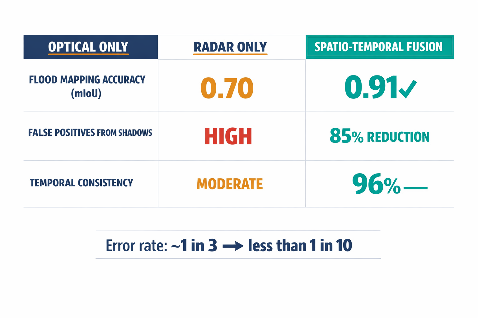
Our benchmarks tell a clear story:
False positive rate from shadows: reduced by 85%. Radar acts as a verification layer that optical-only systems simply don't have.
Flood mapping accuracy (mIoU): above 0.91, compared to roughly 0.65 for optical-only baselines and 0.70 for radar-only baselines.
Temporal consistency: 96%, eliminating the "flickering" output that makes frame-by-frame systems operationally useless.
These aren't improvements at the margin. An optical-only model gets the answer wrong roughly one-third of the time. A spatio-temporal fusion system gets it wrong less than one-tenth.
As climate change drives more frequent extreme weather — and the cloud cover that accompanies it — any flood detection system that fails in the presence of clouds is not just limited. It's obsolete.
When the AI saw a flooded road, a single-frame model panicked. Our system checked the radar, rewound the timeline, verified the temporal consistency, and cleared the road.
The question for any enterprise relying on satellite-based environmental intelligence is straightforward: is your system watching the world, or is it just glancing at snapshots? If your operations have been affected by false environmental alerts — or if you're evaluating AI-driven monitoring for the first time — we'd welcome the conversation about what forensic-grade flood intelligence actually looks like in practice.