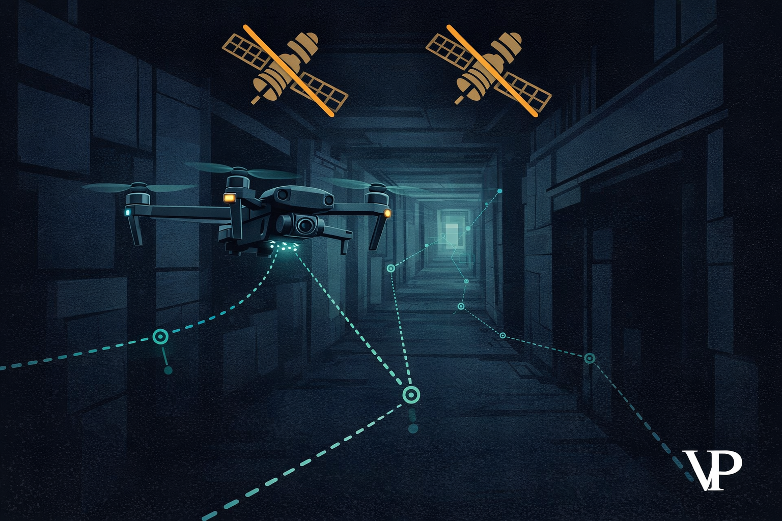
A GPS satellite signal arrives at your drone with roughly the power of a 25-watt light bulb viewed from 10,000 miles away. A $200 jammer a few kilometers away can drown it out completely. When that happens, most commercial drones — the ones we call "autonomous" — lose position, enter failsafe, and either hover helplessly or drop from the sky. In a combat zone, that's a destroyed asset. In a mine shaft, there was never a GPS signal to begin with.
We've spent years studying this problem, and our conclusion is blunt: a drone that depends on GPS for stability is not autonomous. It's automated within a permissive environment. The moment that environment turns hostile — through electronic warfare, underground operations, or even flying near a metal bridge — the system fails. We call this the Autonomy Paradox, and we published our full architectural analysis to lay out both the problem and the engineering path forward.
A $1 Billion-Per-Day Vulnerability
The scale of GPS dependence is staggering. A NIST-sponsored study estimated that GPS generated approximately $1.4 trillion in economic benefits for the U.S. private sector between 1984 and 2017. The flip side: a loss of GPS service would cost the U.S. economy roughly $1 billion per day.
That dependence extends far beyond navigation apps. Drones inspecting oil pipelines, surveying mine shafts, and monitoring critical infrastructure all rely on satellite signals for basic stability. When those signals degrade — or disappear — the mission stops.
A drone that can't navigate without GPS isn't an autonomous system. It's expensive hardware waiting for permission to fly.
In Ukraine, this isn't theoretical. FPV and commercial drones routinely lose GPS within 5–10 kilometers of front-line electronic warfare deployments. Advanced jamming systems provide near-constant area denial across entire operational corridors. Operators are forced back to manual visual piloting — a skill-intensive, feed-dependent fallback that doesn't scale.
Jamming Is the Easy Part. Spoofing Is Worse.
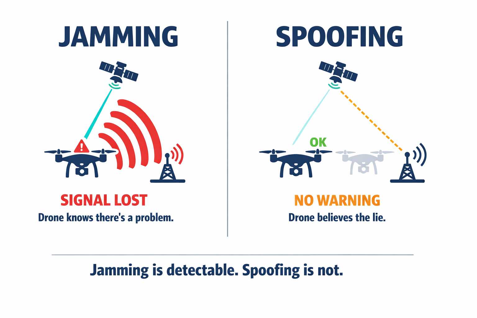
Jamming at least triggers a "signal lost" warning. Spoofing is far more dangerous because the drone doesn't know anything is wrong. An adversary transmits a counterfeit GPS signal at slightly higher power than the real satellites. The drone's receiver locks onto it, and the navigation stack starts quietly lying.
One technique — called meaconing — records real satellite signals and rebroadcasts them with a slight delay. The drone's computed position drifts without any alarm. A more sophisticated approach generates entirely fake constellation data, gradually introducing errors in position, velocity, and time. The drone might believe it's stationary while it's actually moving into hostile territory, or perceive a false altitude change and fly into the ground.
Multi-constellation receivers that track GPS, GLONASS, Galileo, and BeiDou simultaneously raise the difficulty of spoofing, but they don't eliminate it against state-level adversaries capable of broadband signal manipulation.
Why Cloud AI Can't Save You
Some assume the answer is better software — stream the drone's camera feed to a cloud server, run sophisticated AI, send commands back. Our research into control loop physics shows why this fails for anything moving faster than a crawl.
A quadcopter makes hundreds of motor adjustments per second. High-level guidance commands — avoid that obstacle, track that target — must arrive within milliseconds. But cloud round-trips, accounting for upload, processing, and download, commonly introduce 300 milliseconds of delay. For a drone moving at 20 meters per second, that's 6 meters of blind travel. Research shows that teleoperation becomes practically uncontrollable above 700 milliseconds of latency.
Worse than constant delay is jitter — unpredictable variation in latency. A control algorithm can be tuned for a known, fixed delay. Random spikes destabilize the feedback loop, causing oscillation. In a contested environment where electronic warfare systems are actively inducing noise, network jitter becomes the norm.
The problem isn't bandwidth or 5G speeds. It's physics. Light has a speed limit, and drones don't wait for your server to respond.
There's also the electromagnetic signature problem. A drone streaming video to the cloud is broadcasting its position to anyone with a direction-finding antenna. In defense applications, radio silence is survival. Cloud-dependent AI makes stealth impossible.
How Eyes and an Inner Ear Replace Satellites
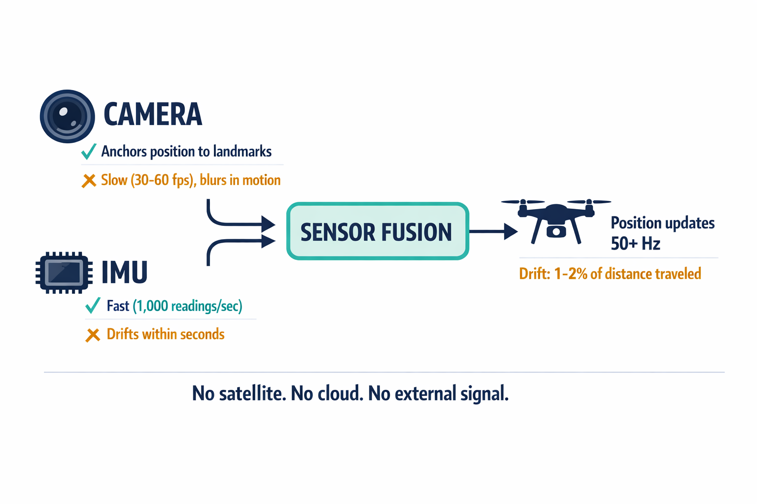
The solution our team engineers around is called Visual Inertial Odometry, or VIO — and the concept is borrowed from biology. Your brain fuses what your eyes see with what your inner ear senses (acceleration, rotation) to know where you are, even in the dark. VIO does the same thing for a drone, combining camera data with readings from an Inertial Measurement Unit (IMU) — essentially a set of accelerometers and gyroscopes.
Neither sensor works well alone. Cameras are relatively slow (30–60 frames per second) and blur during fast maneuvers. A single camera can tell the drone it's moving forward, but not whether it moved 1 meter or 10. IMUs are fast (up to 1,000 readings per second) but drift catastrophically — a consumer-grade IMU can accumulate meters of error within seconds because tiny measurement errors compound over time.
Fused together, each sensor covers the other's weakness. The IMU handles rapid movements where images would blur. The camera anchors the drifting IMU estimate to fixed landmarks in the real world. The result: drift rates as low as 1–2% of distance traveled, even with zero GPS signal. No satellite. No cloud. No external signal of any kind.
VIO is un-jammable for a simple reason: it's passive. There's no signal to intercept, no frequency to overwhelm. The drone sees and feels its way through space.
When the Drone Recognizes Where It's Been
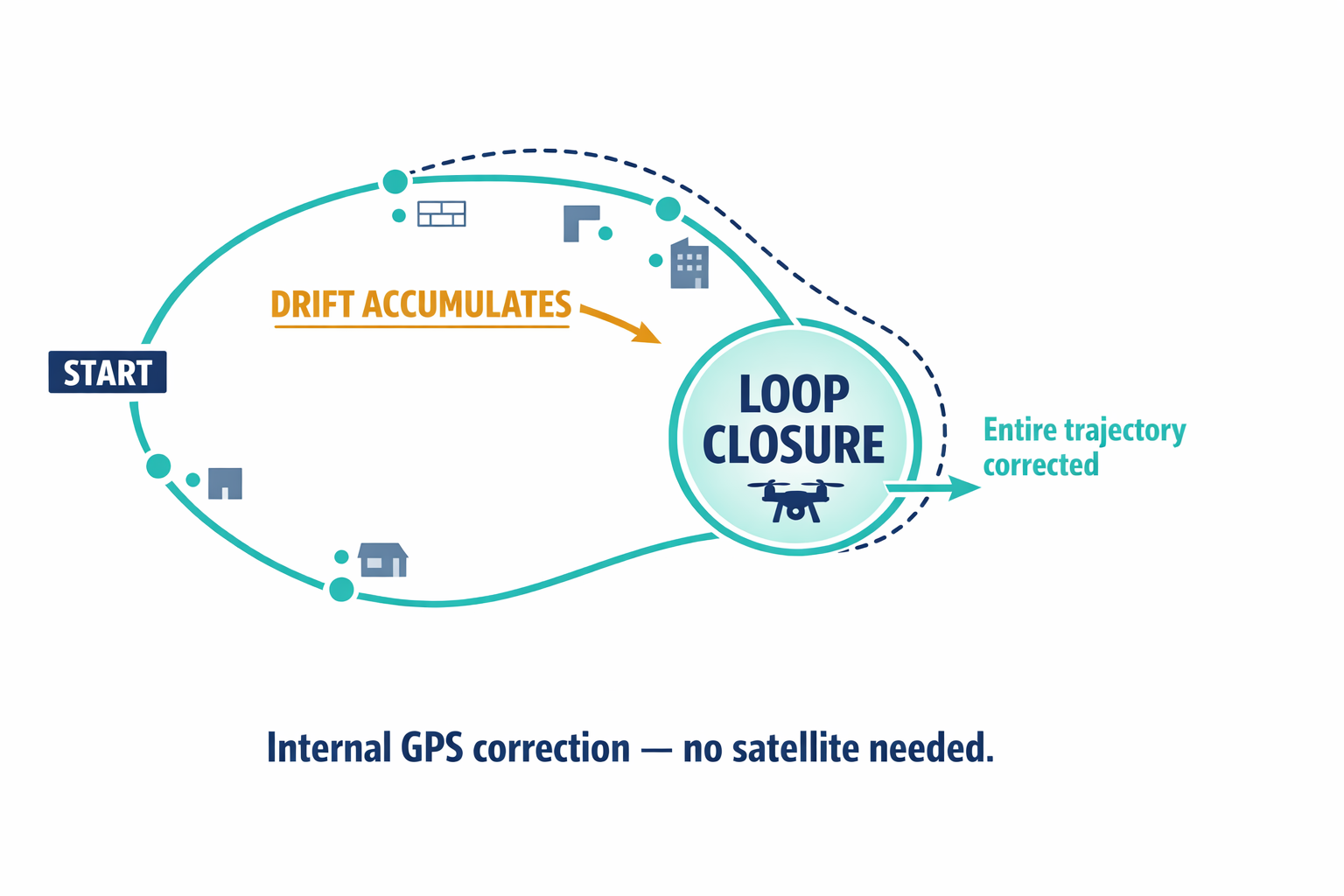
VIO solves the local problem — the drone knows it moved 5 meters forward. But small errors still accumulate over long flights. Without correction, a drone inspecting a 10-kilometer pipeline will gradually drift off course.
This is where VIO evolves into something called SLAM — Simultaneous Localization and Mapping. The drone builds a map of its environment as it flies. When it returns to a previously visited area, it matches what it currently sees against its stored map. If it recognizes the location, it calculates how much drift has accumulated since the last visit and corrects the entire trajectory at once. Roboticists call this loop closure, and it functions like an internal GPS correction — without any satellite.
Our stack builds on ORB-SLAM3, an open-source framework we've enhanced with deep-learning-based feature extraction. Traditional feature detectors struggle in challenging lighting — dawn, dusk, harsh shadows. Neural network-based alternatives like SuperPoint maintain performance where classical methods fail, which matters enormously for real-world operations that don't happen in controlled lighting.
We take this further with what's called Semantic SLAM. Standard SLAM treats the world as a cloud of meaningless points. Semantic SLAM understands what those points represent — "door," "wall," "vehicle," "person." This matters for two practical reasons. First, the system knows that a moving truck isn't a stationary landmark, so it excludes those features from its calculations instead of being fooled by them. Second, semantic features are stable across lighting changes. A "window" looks different at noon versus midnight in raw pixels, but the concept of "window" persists, enabling recognition across time of day.
For a deeper look at how these systems are architected and benchmarked, our team published the full technical methodology covering sensor fusion approaches, algorithm selection, and hardware optimization.
Fitting a Brain Inside a Drone
Running real-time visual navigation and neural networks simultaneously demands serious computing power — but it has to fit on a flying machine with strict weight and power budgets. This is where Edge AI stops being a buzzword and becomes a hardware engineering problem.
Our primary compute platform is the NVIDIA Jetson Orin NX, which delivers 100 trillion operations per second of AI performance while consuming just 10–25 watts. For context, that's server-class AI capability in a module smaller than a credit card. It runs our VIO backend alongside object detection networks without exceeding the thermal limits of a tactical drone.
Raw silicon isn't enough, though. We use NVIDIA's TensorRT compiler to optimize neural networks — converting model weights from 32-bit floating point to 8-bit integers, which can double or triple processing speed with minimal accuracy loss. Feature tracking and optical flow get offloaded to dedicated vision accelerator cores, freeing the GPU for deep learning. The map optimization runs on parallelized GPU kernels. This heterogeneous approach ensures the flight controller receives position updates at over 50 times per second, regardless of scene complexity.
What This Changes Across Industries
In defense, GPS denial is now a certainty in any serious conflict. VIO-equipped drones can visually lock onto a target and complete a strike autonomously, even after losing their command link. They navigate contested corridors in radio silence — invisible to standard RF scanners. A single operator can deploy a swarm that perceives, decides, and acts without emitting a single transmission.
In mining, the environment is naturally GPS-denied. After blasting, stopes fill with dust and toxic gases. Sending humans in for inspection is dangerous and slow — manual surveys can take days. A VIO-enabled drone with LiDAR fusion flies in immediately, inspects rock fragmentation and structural stability, and returns data in minutes.
In infrastructure inspection, the economics are stark. A single pipeline failure can cost $8.5 million; catching it early through drone inspection costs a fraction of that. But pipelines run under bridges, between storage tanks, through urban canyons — all GPS shadow zones where multipath effects corrupt position by meters. VIO maintains centimeter-level station-keeping in exactly the environments where GPS fails, enabling the high-resolution imaging that makes predictive maintenance possible.
The ROI of drone inspection assumes the drone can actually fly where you need it. Without GPS-independent navigation, that assumption breaks in exactly the locations that matter most.
What About Environments Where Cameras Struggle?
Fair question. VIO relies on tracking visual texture — contrast, corners, edges. Environments with blank white walls, dense fog, smoke, or open water can cause tracking loss. Our mitigation is LiDAR-VIO fusion: integrating a lightweight solid-state LiDAR sensor that provides dense geometric data in total darkness or featureless voids, anchoring the visual system when cameras alone aren't enough.
Dynamic environments pose a different challenge. If the drone tracks a moving forklift and mistakes it for a stationary wall, it miscalculates its own motion. This is where semantic masking earns its place — the neural network identifies moving objects pixel by pixel and excludes them from the navigation pipeline entirely.
Neither problem is trivial, but both have engineered solutions that work within the power and weight constraints of a flying platform. The key insight is that VIO's failure modes are addressable through sensor fusion and software. GPS's failure mode — signal denial — has no onboard fix.
The Line Between Automated and Autonomous
The distinction matters more than it might seem. An automated system executes a pre-defined script based on external inputs: GPS coordinates, pilot commands, cloud instructions. Remove those inputs, and the system stops. A truly autonomous system perceives its environment, determines its own state, and makes decisions without external reliance.
Most of what the drone industry calls "autonomy" is automation running in a permissive environment. Our work focuses on the harder problem: building systems that remain capable when the environment turns non-permissive. Un-jammable navigation through passive sensing. Un-tethered operation without radio links or cloud connectivity. Onboard intelligence that doesn't need to phone home.
For the defense commander, the mine operator, and the infrastructure manager, this isn't an academic distinction. It's the difference between a system that completes its mission and one that becomes a paperweight.
We'd welcome hearing from teams navigating these challenges in their own operations — whether military, industrial, or somewhere we haven't considered yet.