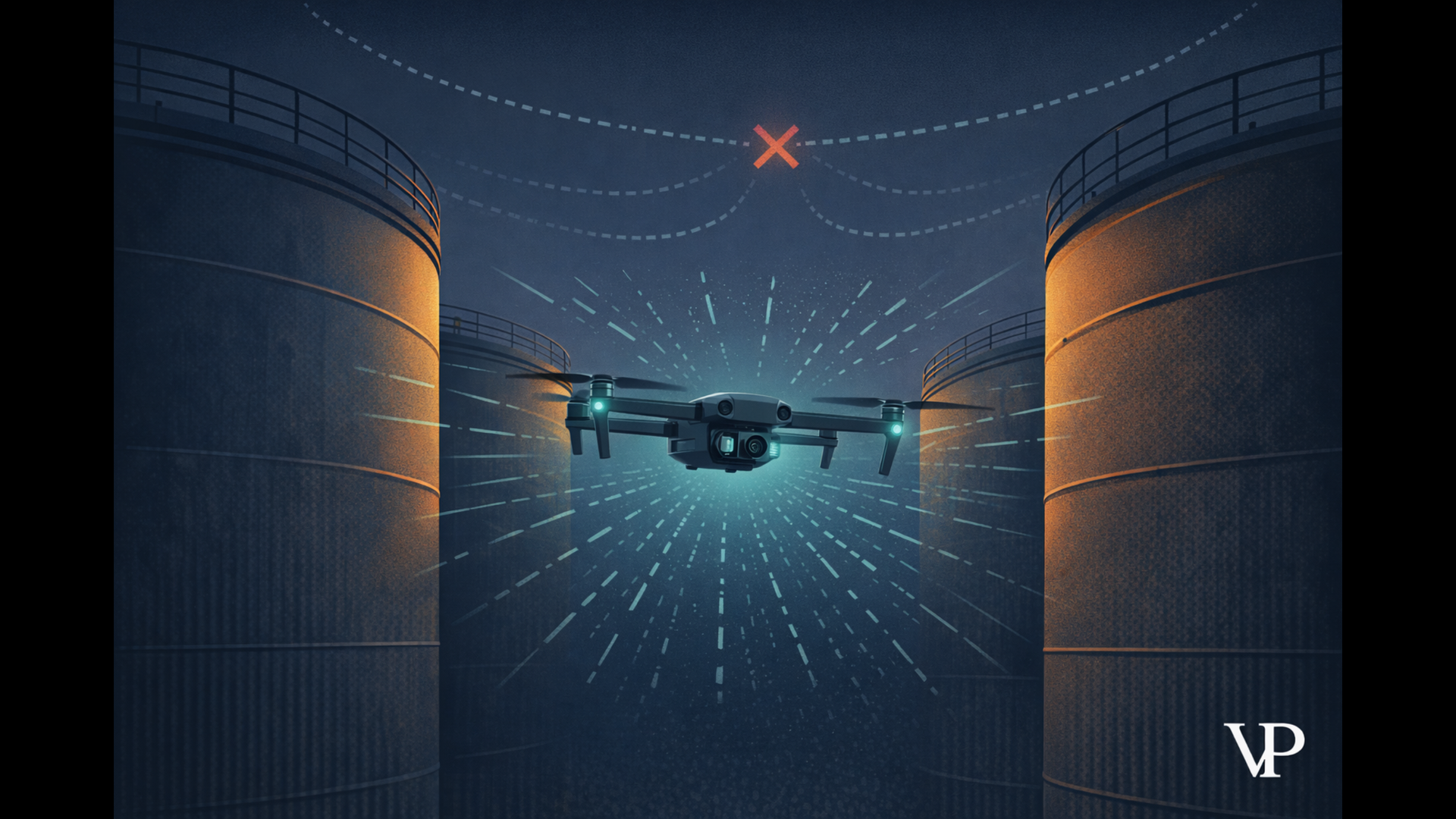
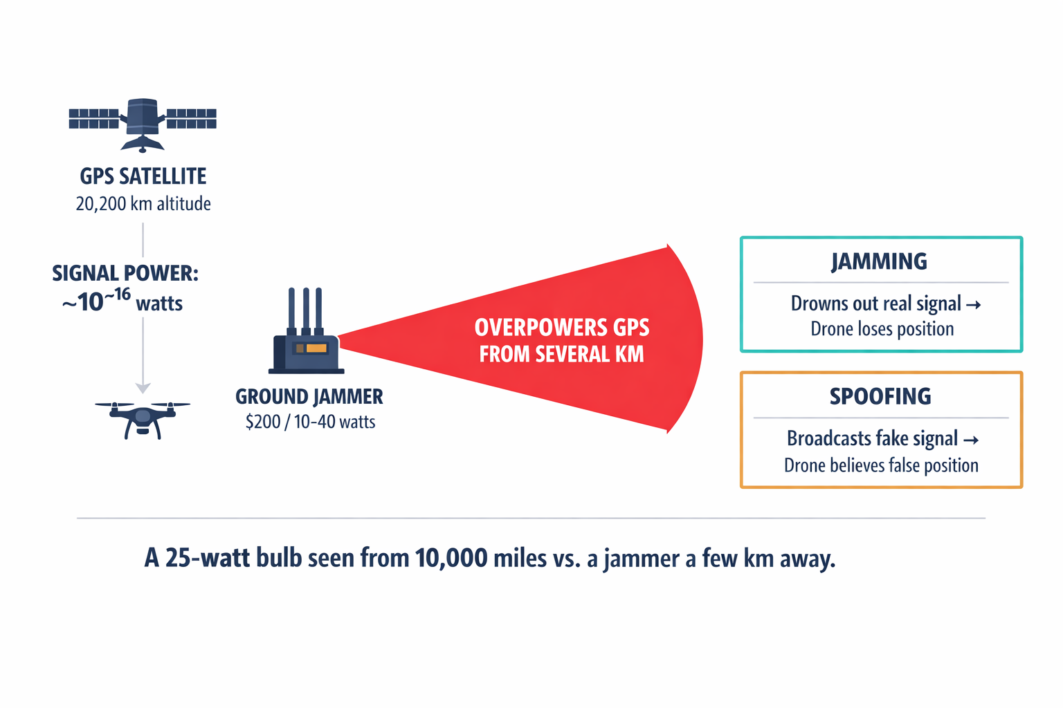
A GPS satellite signal arrives at your drone with roughly the power of a 25-watt light bulb seen from 10,000 miles away. A $200 jammer on the ground can drown it out from a few kilometers. In Ukraine right now, commercial quadcopters routinely lose GPS within 5–10 km of front-line electronic warfare systems. The most expensive drone in the world, if it depends on satellites for stability, becomes a paperweight the moment someone flips a switch.
I've spent the last several years obsessed with a question that most of the drone industry would rather not answer honestly: what happens to your "autonomous" system when the signals it depends on disappear?
The answer, almost always, is that it fails. It hovers helplessly, lands in the wrong place, or drifts into a structure. And that failure reveals something uncomfortable — most drones we call autonomous aren't autonomous at all. They're automated. They follow pre-programmed scripts fed by external signals. Take away the signal, and there's nothing left.
The Trillion-Dollar Assumption
GPS generated approximately $1.4 trillion in economic benefits for the U.S. private sector between 1984 and 2017. A loss of GPS service would cost the U.S. economy roughly $1 billion per day. We've built an extraordinary amount of critical infrastructure on top of a signal that can be defeated by physics, geography, or a motivated adversary.
This isn't just a military problem. Fly a drone near a cluster of oil storage tanks, and GPS signals bounce off metal surfaces before reaching the receiver — a phenomenon called multipath. The timing calculation corrupts, and your position drifts by several meters. Try to inspect the underside of a bridge, and you're in a GPS shadow. Fly into an underground mine, and satellites simply don't exist.
A drone that can't navigate without GPS isn't autonomous. It's automated in a permissive environment.
The distinction matters enormously. In a mine, a crashed drone means a $50,000 asset destroyed. On a pipeline, a single missed inspection can lead to a failure costing millions in cleanup and fines — versus $75,000 for a timely repair. In a warzone, a hovering drone with no GPS is a stationary target.
Why Jamming Is the First Move in Modern Warfare
I want to explain why this vulnerability is so easily exploited, because it shapes everything about how we approach navigation.
GPS satellites orbit about 20,200 kilometers overhead. By the time their signals reach Earth, they're extraordinarily faint. A ground-based jammer doesn't need to be powerful — it just needs to be close. Even portable jammers operating at 10–40 watts create blackout zones extending several kilometers. Advanced systems like Russia's R-330Zh Zhitel provide near-constant area denial over entire sectors of the front line.
But jamming is the blunt instrument. Spoofing is the scalpel. Instead of drowning out the signal, an adversary broadcasts a counterfeit GPS signal at slightly higher power. Your drone doesn't know it's been deceived — it locks onto the fake signal and believes it's somewhere it's not. It might think it's stationary while drifting into hostile territory, or perceive a false altitude and fly straight into the ground.
What struck me when we first studied this deeply was how the entire electronic warfare playbook targets not just navigation but the command-and-control link too. Wideband jammers hit the 2.4 GHz and 5.8 GHz frequencies that drones use to communicate with their operators. Sever that link, and a drone without onboard intelligence enters failsafe mode — hovering or landing immediately. In combat, that's a death sentence. In industrial operations, it's an uncontrolled landing on expensive equipment.
We published a detailed analysis of these failure cascades that traces the problem from the physics of signal vulnerability through to the operational consequences across defense, mining, and infrastructure.
The Cloud AI Trap
There's a second fragility that compounds the GPS problem, and the industry talks about it even less: cloud-dependent AI.
The standard model works like this — stream video from the drone to a cloud server, run object detection or mapping algorithms remotely, send commands back. It sounds elegant. It falls apart in practice for a reason rooted in physics.
A drone moving at 20 meters per second covers 6 meters during a typical 300-millisecond cloud round-trip. Six meters of blind flight. And that's the average case. What kills you is the worst case — the 99th percentile latency spike caused by network congestion or a cell tower handover. Research shows that teleoperation becomes practically uncontrollable above 700 milliseconds of delay. Even worse than raw latency is jitter, the unpredictable variation in delay. You can tune a control system for a constant delay. You cannot tune it for randomness.
At 20 meters per second, a 300-millisecond cloud round-trip means 6 meters of blind flight. That's not a latency problem — it's a wall.
There's also the electromagnetic signature problem. A drone streaming video to the cloud is broadcasting continuously on known frequencies. In a defense context, that's a beacon for enemy direction-finding equipment. In any context, it's a dependency on network coverage that may not exist where you need to fly.
When we process everything onboard — at the edge — the drone only transmits when it chooses to. A burst of compressed results, not a firehose of raw video. Bandwidth drops by orders of magnitude. The drone can operate in complete radio silence.
How We Teach a Drone to Navigate Like a Human
So if you can't rely on satellites and you can't rely on the cloud, what's left?
Think about how you navigate a dark, unfamiliar building. Your eyes track landmarks — a doorframe, a crack in the wall, the corner of a desk. Your inner ear tells you whether you're turning, accelerating, tilting. Your brain fuses these two streams constantly, using your eyes to correct the drift your inner ear accumulates, and your inner ear to fill in the gaps when your eyes can't keep up.
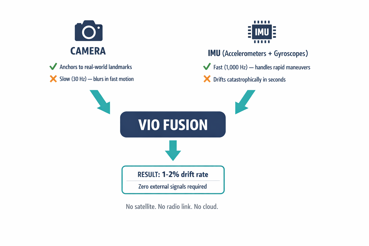
That's exactly what Visual Inertial Odometry — VIO — does for a drone. A camera tracks distinctive visual features across successive frames, estimating how the drone has moved. An Inertial Measurement Unit (IMU), essentially a cluster of accelerometers and gyroscopes, provides high-frequency motion data — a thousand readings per second compared to the camera's thirty.
Neither sensor works alone. A camera is too slow to handle rapid maneuvers and can't judge absolute distance with a single lens. An IMU drifts catastrophically — small measurement errors compound quadratically over time, producing meters of error within seconds. But fused together, they cancel each other's weaknesses. The IMU handles the fast, aggressive movements where images would blur. The camera anchors the drifting IMU to fixed landmarks in the real world.
The result: drift rates as low as 1–2% of the distance traveled, with zero dependence on any external signal. No satellite. No radio link. No cloud. Just physics and math running on hardware strapped to the airframe.
When Vision Fails — And What We Do About It
I don't want to oversell this. VIO is un-jammable, but it's not infallible, and being honest about the failure modes is what separates engineering from marketing.
The most obvious vulnerability: feature-poor environments. VIO needs visual texture — contrast, corners, edges. A white wall, dense fog, smoke filling a mine shaft after blasting — these starve the algorithm of the landmarks it needs to track.
Our mitigation is sensor fusion with lightweight solid-state LiDAR. LiDAR fires laser pulses and measures their return time, generating dense geometric data that works in total darkness or when cameras see nothing useful. The LiDAR point cloud provides structural constraints that keep the navigation solution anchored when vision alone would fail.
The second vulnerability is subtler: dynamic environments. Standard VIO assumes the world is static. If the algorithm tracks features on a moving truck and treats them as stationary landmarks, it will miscalculate the drone's own motion to compensate. The drone thinks it moved when it didn't, or vice versa.
This is where deep learning enters the navigation stack. We run semantic segmentation models — neural networks that classify every pixel in the image — to identify objects that are likely to move: vehicles, people, foliage in wind. Those pixels get masked out of the navigation pipeline entirely, so the drone only tracks the static background. We started calling this approach semantic masking, and it transformed our reliability in cluttered, busy environments.
From Odometry to Understanding Space
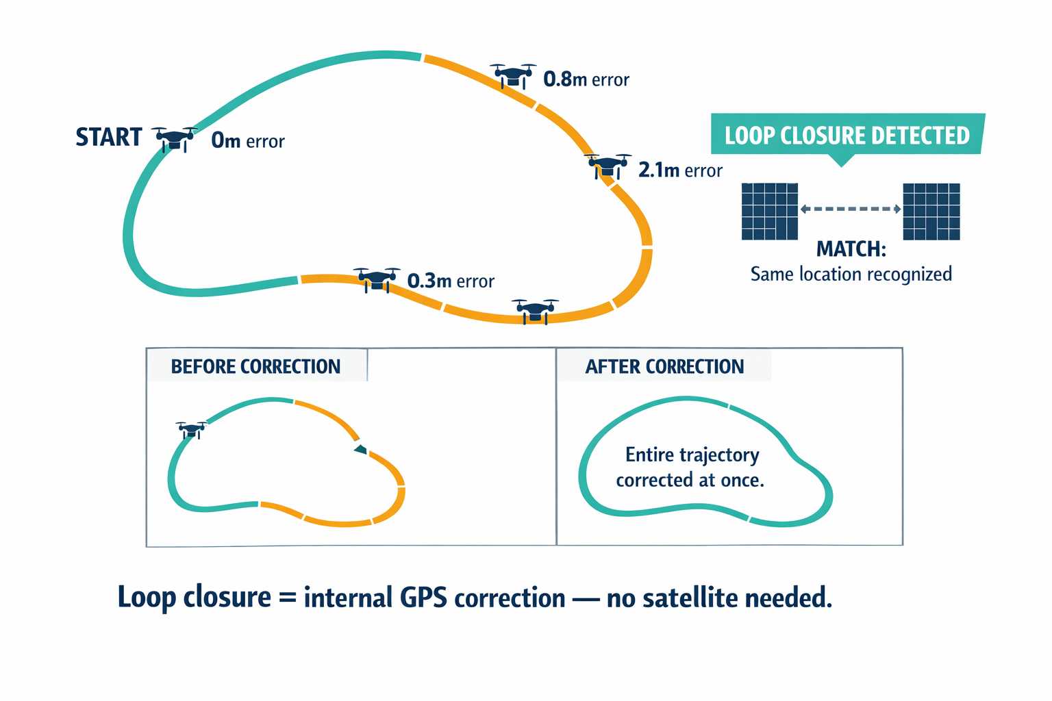
VIO gives you local accuracy — "I moved 5 meters forward and turned 30 degrees left." But over long distances, small errors accumulate. Fly a kilometer-long pipeline inspection route, and you might be meters off course by the end.
The solution is SLAM — Simultaneous Localization and Mapping. The drone builds a map of its environment as it flies and uses that map to recognize places it's been before. When it returns to a previously visited area, it matches the current visual fingerprint against its stored map, calculates how much drift has accumulated, and corrects the entire trajectory at once. Roboticists call this loop closure, and it functions as an internal GPS correction — without any satellite.
Loop closure is the drone's internal GPS. It recognizes where it's been and snaps its entire trajectory back into alignment — no satellite required.
What excites me most is the leap from geometric SLAM to semantic SLAM. Traditional SLAM sees the world as a cloud of meaningless points. Our system sees "door," "wall," "storage tank," "structural crack." This matters for three reasons.
First, it makes the system robust in dynamic scenes — it knows a car is something that moves and excludes it from the map automatically. Second, semantic features survive lighting changes. A pixel-level corner looks different at noon versus midnight, but the concept of a "window" remains recognizable. A drone that mapped a facility during the day can navigate it at night. Third, it enables human-level commands: "inspect the red tank" instead of "fly to coordinate 34.0522, -118.2437."
The Hardware That Makes This Possible
All of this math — non-linear optimization for VIO, neural networks for semantic segmentation, graph-based SLAM — has to run on a computer small enough to fly. This is where I get genuinely excited about where the technology has arrived.
The NVIDIA Jetson Orin NX delivers 100 trillion operations per second of AI performance in a module that draws 10–25 watts. That's a 3x to 5x leap over the previous generation. It lets us run our modified ORB-SLAM3 navigation stack alongside real-time object detection networks without blowing the thermal budget of a small drone.
But raw silicon isn't enough. We use NVIDIA's TensorRT compiler to optimize our neural networks — fusing layers, selecting efficient computational kernels, and quantizing weights from 32-bit floating point down to 8-bit integers. This alone can double or triple inference speed. We offload feature tracking to dedicated vision accelerator cores on the chip, freeing the GPU for deep learning. The navigation backend's heavy optimization math runs in parallel on GPU compute cores.
The result is odometry updates at 50+ Hz — fast enough for the flight controller to keep the drone stable during aggressive maneuvers — with simultaneous semantic understanding of the entire scene. Everything onboard. Nothing in the cloud.
For the full technical architecture — the specific algorithms, benchmark comparisons, and hardware trade-offs — we published a comprehensive technical deep-dive that goes well beyond what I can cover here.
What This Changes Operationally
The moment a drone can navigate and think without external signals, entirely new operations become possible.
In defense, a VIO-equipped drone can lock onto a target visually and complete its mission even after the command link is severed. It doesn't broadcast, so it's invisible to RF scanners. A single operator can deploy a swarm through a GPS-denied corridor — each drone navigating independently, identifying targets with onboard AI, acting on pre-set rules of engagement. The force multiplication is enormous.
In mining, drones can fly into dark, dust-filled stopes immediately after blasting to inspect rock fragmentation and structural stability — environments where humans face toxic gases and collapse risk, and where GPS has never existed. What used to take a survey team days now takes 30 minutes.
In infrastructure, drones maintain centimeter-level station-keeping in GPS shadows — under bridges, between storage tanks, inside urban canyons — capturing the high-resolution imagery that predictive maintenance depends on. Drone inspection already cuts costs by up to 70% compared to manned helicopters. But that ROI only materializes if the drone can actually fly where the problems are.
What About Cost and Complexity?
The obvious objection: this sounds expensive and hard. It is hard — I won't pretend otherwise. Integrating VIO, semantic SLAM, and edge AI into a reliable flight system requires deep sensor-fusion engineering, not API calls. The Jetson hardware adds cost and weight compared to a basic GPS-only flight controller.
But consider the alternative. A $50,000 industrial drone that crashes in a mine because it lost stability. A pipeline leak that goes undetected because the drone couldn't hold position near a tank farm. A military asset lost because a $200 jammer turned it into debris. The cost of fragility dwarfs the cost of resilience.
The real question isn't whether you can afford onboard intelligence. It's whether you can afford to deploy systems with a single point of failure that's vulnerable to both a nation-state adversary and a concrete wall.
The Line Between Automated and Autonomous
I keep coming back to a distinction that I think the industry needs to take more seriously. An automated system executes a script. An autonomous system perceives, decides, and acts on its own. Most of what we call autonomous today is automated within a permissive environment — an environment where GPS works, the network is up, and nobody is actively trying to interfere.
The environments that matter most — contested airspace, underground mines, GPS-shadowed infrastructure — are not permissive. Building systems that only work when everything goes right is building systems that fail when they're needed most.
I'd be curious to hear from anyone working in defense, mining, or industrial inspection: how are you handling GPS-denied operations today? What's working, and what's still breaking?